|
Good morning. This will be the final update on the Belknap Fire unless conditions change. Thanks, Jackie Jacqueline C. Banks Public Affairs Officer Kaibab National Forest Office: 928-635-8314 Cell: 928-606-7490
Kaibab
National Forest For
Immediate
Release – Sept. 4, 2014
Contacts:
Jacqueline
Banks, 928-635-8314; Bob Blasi, 928-606-7491
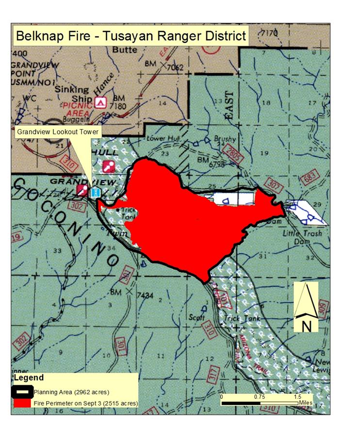
Belknap Fire Nearly Reaches Final Size
TUSAYAN, Ariz. – The resource-benefit fire that is burning
on the Tusayan Ranger District of the Kaibab National Forest has almost reached its expected final size, having treated 2,515 acres of the 2,962-acre planning area established for it by fire managers.
Yesterday, crews used both aerial and hand ignitions within the perimeter of the Belknap Fire area, which is located 12 miles east of Tusayan on the Coconino Rim. A total of 1,359 acres was treated with fire,
achieving resource objectives such as improving forest health and reducing the likelihood of future high-severity fires.
“The Coconino Rim is one the very few forested areas on the Tusayan district that has not seen widespread fire entry in many years,” said Holly Kleindienst, deputy fire staff officer for the Kaibab National
Forest. “In that area, wildfire is the most efficient and cost effective way to reduce the threat of high-severity fire effects.”
Today, fire managers plan to complete managed ignitions on the remaining 400-plus acres left within the planning area. Efforts will be focused along Forest Road 310 near Grandview Lookout Tower to ensure
containment lines are secure.
With monsoon showers predicted to return to the area today, and given that the lightning-caused Belknap Fire has nearly reached its final planned size, fire managers expect to complete all managed ignitions
by this afternoon and begin demobilizing fire resources tonight.
Over the next few days, crews will focus on removing hazards within the fire area and rehabilitating containment lines that were created as boundaries for the fire. A detour remains in place for the Arizona Trail sections within the Belknap Fire area. The trail detour follows Forest Road 310.
Signs and detour maps have been posted in the vicinity for Arizona Trail users. Over the next few days, fire managers will evaluate conditions along the trail to determine the appropriate time to reopen it.
“I am extremely pleased with the success we’ve had with managed fire this year on the Kaibab National Forest,” said Mike Williams,
forest supervisor. “We have been able to treat more than 28,000 acres since the monsoons began, which is an incredible accomplishment and a huge step toward improving forest conditions in those areas.” Additional information, photos and maps are available at the following locations:
This electronic message contains information generated by the USDA solely for the intended recipients. Any unauthorized interception of this message or the use or disclosure of the information it contains may violate the law and subject the violator to civil or criminal penalties. If you believe you have received this message in error, please notify the sender and delete the email immediately. |


Attachment:
1650-1_so_belknap_fire_2014_0904.pdf
Description: 1650-1_so_belknap_fire_2014_0904.pdf
