|
Kaibab National Forest
Website:
www.fs.usda.gov/kaibab Twitter:
www.twitter.com/KaibabNF Inciweb:
inciweb.nwcg.gov
For Immediate Release Contact: Jackie Banks, 928-635-8314 September 2, 2014
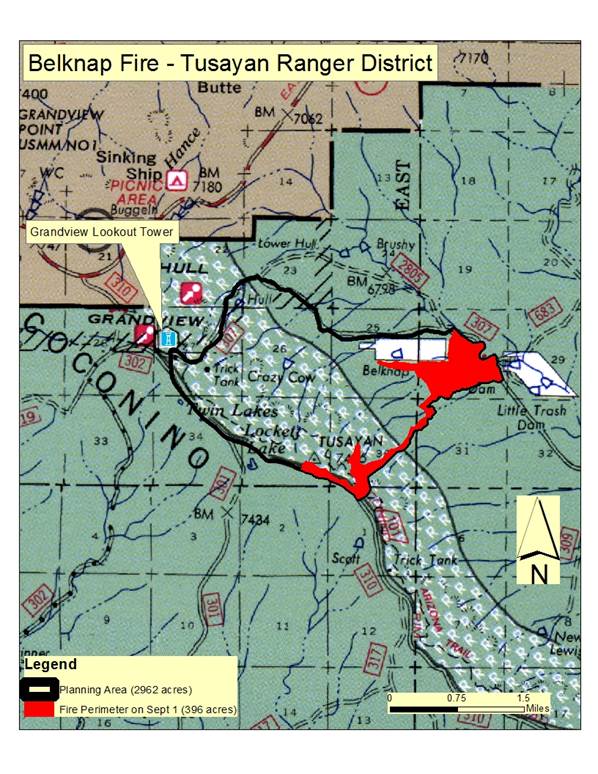
Belknap Fire Reaches 396 Acres; Ignitions Planned
TUSAYAN, Ariz – Yesterday, crews conducted limited hand ignitions along the steep terrain at the eastern perimeter of the fire
planning area. All handline constructed in that area held overnight and helped establish a strong perimeter line to the east. Today, fire managers plan to conduct both hand and aerial managed ignitions along the Coconino Rim near FSR 310 in a westward progression.
Managed ignitions placed strategically along these ridge tops will allow fire to back down slope at lower intensities. Low to moderate fire intensity is an essential part of removing hazardous fuels, opening dense tree stands, improving wildlife habitat, and
protecting cultural resources. Date/Time Reported: Tuesday August
26, 2014 Location: Southeast of Grandview
Point and HWY 64 Cause: Lightning Size: 396 acres Landscape/Fuels:
Ponderosa Pine and Pinyon/Juniper Fire Behavior:
Majority Low to Moderate Intensity Trail Detour: Due to planned managed
ignitions and active fire hazards, all Arizona Trail sections within the planning area have been temporarily detoured to follow FSR 310.
Large signage and detour maps have been posted in the vicinity for notification.
Variable winds, precipitation, and management tactics can change the amount of visible smoke each day. Currently, smoke is highly
visible from sections of HWY 64 in the Desert View area of the Grand Canyon National Park and near Cameron, Ariz. For more information on smoke and air quality please visit
www.azdeq.gov
or www.wildlandfire.az.gov
. Get fire activity updates and maps 24 hours-a-day: Fire Information Line: 928-635-8311 Inciweb:
inciweb.nwcg.gov Text Message: text ‘follow kaibabnf’ to 40404
Map of the Belknap Fire as of September 1, 2014 with completed managed igntions in red. Holly Krake, MSEd Fire Information Officer USDA Forest Service Kaibab National Forest- South Zone 742 S. Clover Road Williams, AZ 86046 p. 928-635-5653 f. 928-635-5680
This electronic message contains information generated by the USDA solely for the intended recipients. Any unauthorized interception of this message or the use or disclosure of the information it contains may violate the law and subject the violator to civil or criminal penalties. If you believe you have received this message in error, please notify the sender and delete the email immediately. |


Attachment:
1650-1_d4_Belknap_Fire_2014_0902.pdf
Description: 1650-1_d4_Belknap_Fire_2014_0902.pdf
