|
Kaibab National Forest
Website:
www.fs.usda.gov/kaibab Twitter:
www.twitter.com/KaibabNF Inciweb:
inciweb.nwcg.gov
For Immediate Release Contact: Holly Krake, 928-635-5653 September 1, 2014
Work Continues on Belknap Fire; Arizona Trail Detoured
TUSAYAN, Ariz – Yesterday, the lightning caused Belknap Fire continued to actively spread to the northwest growing to 307 acres
in size. Low to moderate fire behavior throughout the day helped reduce hazardous fuels on the forest floor with minimal smoke impacts. Crews worked in steep terrain down the Coconino Rim to build handline and protect resources along the eastern perimeter
of the planning area. Today, fire managers anticipate some managed ignitions along the eastern side of the planning area to strengthen the perimeter
line there. Crews plan to start these ignitions along the tops of ridges to slowly back fire down the Coconino Rim at lower intensities. Over the next several days, fire managers may continue managed ignitions along the ridge tops in a westward progression
as needed. Date/Time Reported: Tuesday August
26, 2014 Location: Southeast of Grandview
Point and HWY 64 Cause: Lightning Size: 307 acres Landscape/Fuels:
Ponderosa Pine and Pinyon/Juniper Fire Behavior:
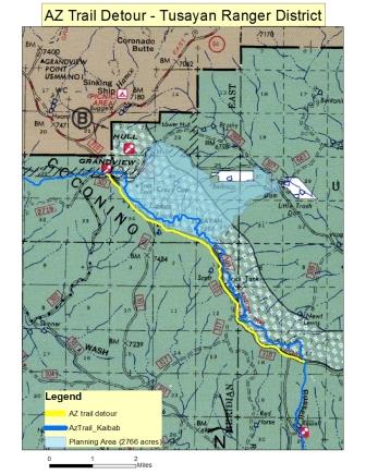
Majority Low to Moderate Intensity Trail Detour: Due to planned managed
ignitions and active fire hazards, all Arizona Trail sections within the planning area have been temporarily detoured to follow FSR 310.
Large signage and detour maps have been posted in the vicinity for notification.
Variable winds, precipitation, and management tactics can change the amount of visible smoke each day. Currently, smoke is highly
visible from sections of HWY 64 in the Desert View area of the Grand Canyon National Park and near Cameron, Ariz. For more information on smoke and air quality please visit
www.azdeq.gov
or www.wildlandfire.az.gov
. Get fire activity updates and maps 24 hours-a-day: Fire Information Line: 928-635-8311 Inciweb:
inciweb.nwcg.gov Text Message: text ‘follow kaibabnf’ to 40404
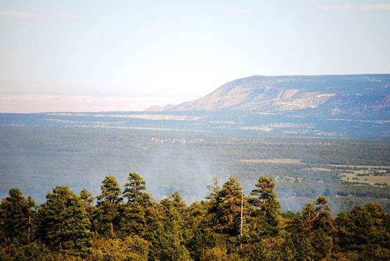
Light smoke from the Belknap Fire rises above the treetops to the south of
Grandview Lookout Tower.
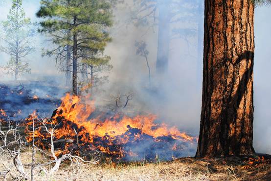
Low intensity fire removes hazardous fuels from the forest floor on the Belknap Fire. Holly Krake, MSEd Fire Information Officer USDA Forest Service Kaibab National Forest- South Zone 742 S. Clover Road Williams, AZ 86046 p. 928-635-5653 f. 928-635-5680
This electronic message contains information generated by the USDA solely for the intended recipients. Any unauthorized interception of this message or the use or disclosure of the information it contains may violate the law and subject the violator to civil or criminal penalties. If you believe you have received this message in error, please notify the sender and delete the email immediately. |


Attachment:
1650-1_d4_Belknap_Fire_2014_0901.pdf
Description: 1650-1_d4_Belknap_Fire_2014_0901.pdf
Attachment:
Arizona Trail Detour Map 09.01.14 1.jpg
Description: Arizona Trail Detour Map 09.01.14 1.jpg
