|
Kaibab National Forest
Website:
www.fs.usda.gov/kaibab Twitter:
www.twitter.com/KaibabNF Inciweb:
inciweb.nwcg.gov
For Immediate Release Contact: Holly Krake, 928-635-5653 August 31, 2014
Belknap Fire to Benefit Forest; 300 Acres in Size TUSAYAN, Ariz – On August 26, 2014 fire personnel reported located the Belknap Fire near the Grandview Lookout Tower. With the
return of favorable conditions, fire managers are taking advantage of drier weather to allow this lightning fire to benefit the forest and surrounding communities by reducing hazardous fuels, opening dense tree stands, improving wildlife habitat, and protecting
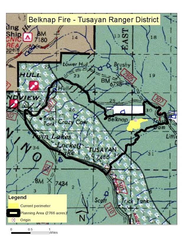
cultural resources. Yesterday, the fire reached 300 acres and burned primarily to the northeast. To plan for fire growth, officials have identified
a specific planning area of approximately 2,766 acres in which the fire could spread. “We have had a tremendously successful year in managing natural fires to play their role in keeping the forest healthy and our communities safer” said District Ranger, James
Simino. “However, we’ve listened to community smoke concerns and we will continue to do everything we can to minimize smoke impacts in the Grand Canyon National Park and adjacent Navajo Nation lands.” Variable winds, precipitation, and management tactics can change the amount of visible smoke each day. While varying monsoonal
precipitation and winds are likely to change fire behavior and growth over the next several days, general fire behavior is anticipated to be low to moderate intensity. For more information on smoke and air quality please visit
www.azdeq.gov
or www.wildlandfire.az.gov
. Date/Time Reported: Tuesday August
26, 2014 Location: Southeast of Grandview
Point and HWY 64 Cause: Lightning Size: 300 acres Landscape/Fuels:
Ponderosa Pine and Pinyon/Juniper Fire Behavior:
Majority Low to Moderate Intensity Get fire activity updates and maps 24 hours-a-day: Fire Information Line: 928-635-8311 Inciweb:
inciweb.nwcg.gov Text Message: text ‘follow kaibabnf’ to 40404
A map of the Belknap Fire at 300 acres (yellow) on August 30, 2014
with the total 2,766 acre planning area outlined in black. Holly Krake, MSEd Fire Information Officer USDA Forest Service Kaibab National Forest- South Zone 742 S. Clover Road Williams, AZ 86046 p. 928-635-5653 f. 928-635-5680
This electronic message contains information generated by the USDA solely for the intended recipients. Any unauthorized interception of this message or the use or disclosure of the information it contains may violate the law and subject the violator to civil or criminal penalties. If you believe you have received this message in error, please notify the sender and delete the email immediately. |


Attachment:
1650-1_d4_Belknap_Fire_2014_0831.pdf
Description: 1650-1_d4_Belknap_Fire_2014_0831.pdf
