|
Kaibab National Forest
Website:
www.fs.usda.gov/kaibab Twitter:
www.twitter.com/KaibabNF Inciweb:
inciweb.nwcg.gov
For Immediate Release Contact: Holly Krake, 928-635-5653 August 27, 2014
Williams and Tusayan Ranger Districts
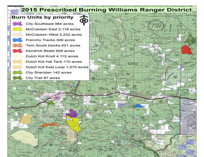
2014-2015 Prescribed Fire Plans WILLIAMS, Ariz. – Starting this September, the Williams and Tusayan Ranger Districts have prescribed (Rx) fire plans for approximately
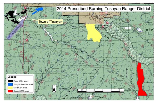
12,700 acres and 4,400 acres respectively. However, significantly fewer acres may be treated through fire if conditions are not favorable. Conditions include correct temperature, wind, fuel moisture, ventilation, and relative humidity. When these criteria
are met, crews implement, monitor, and patrol each burn to ensure it meets the goals and objectives outlined by fire managers.
“We know that during implementation of prescribed fires, firefighter activity, helicopter noise, vehicle traffic, and smoke can
all have an impact to forest users and our communities” said Forest Fire Staff Officer, Art Gonzales. “So we include these concerns into our decision process and work very closely with the National Weather Service and the Arizona Department of Environmental
Quality to minimize these impacts as much as possible while still meeting our goals for forest health and public safety.”
Key goals for prescribed fire include continuing efforts to improve forest health, enhance public safety, and return fire to a
fire-adapted ecosystem. Additionally, prescribed fire lowers the risk of severe wildfires on the forest during critical summer fire conditions by reducing litter, debris, and dense stands of trees. “We’ve made great strides in areas where private businesses
and homes meet the forest, but there is still lots of work to be done in creating defensible spaces” Gonzales added. Before a Rx fire, notification will be provided through multiple channels including; email news releases, Forest fire information
line, Inciweb, Twitter, flyers, and the Forest website. Immediately following a Rx fire, browning of lower level pine needles may occur as the tree crown is raised. This is perfectly normal and healthy. Some areas are also part of long term project work where
future timber marking paint, mechanical thinning equipment, and other impacts may occur.
Get fire activity updates and maps 24 hours-a-day: Fire Information Line: 928-635-8311 Inciweb:
inciweb.nwcg.gov Text Message: text ‘follow kaibabnf’ to 40404 For more information on smoke and air quality please visit
www.azdeq.gov
or wildlandfire.az.gov.
Image 1: Williams Ranger District 2014-2015 Rx Fire Planning Map.
Table 1: Project name, acres, and location description for Williams Ranger District 2014-2015 Rx Fire.
Image 2: Tusayan Ranger District 2014-2015 Rx Fire Planning Map.
Table 2: Project name, acres, and location description for Tusayan Ranger District 2014-2015 Rx Fire.
Holly Krake, MSEd Fire Information Officer USDA Forest Service Kaibab National Forest- South Zone 742 S. Clover Road Williams, AZ 86046 p. 928-635-5653 f. 928-635-5680
This electronic message contains information generated by the USDA solely for the intended recipients. Any unauthorized interception of this message or the use or disclosure of the information it contains may violate the law and subject the violator to civil or criminal penalties. If you believe you have received this message in error, please notify the sender and delete the email immediately. |


Attachment:
1650-1_so_WRD_TRD_Rx_Plans_2014_0827.pdf
Description: 1650-1_so_WRD_TRD_Rx_Plans_2014_0827.pdf
