|
Please see attached advisory regarding the 3200 acre prescribed fire planned near Williams, AZ on the Williams Ranger District on the Kaibab National Forest. For additional maps, daily updates, and pictures of active burns on the Williams Ranger District, please visit inciweb.nwcg.gov
Holly Krake, MSEd Fire Information Officer USDA Forest Service Kaibab National Forest- South Zone 742 S. Clover Road Williams, AZ 86046 p. 928-635-5653 f. 928-635-5680
Kaibab National ForestWebsite: www.fs.usda.gov/kaibabTwitter: www.twitter.com/KaibabNF Inciweb: inciweb.nwcg.gov
For Immediate Release Contact: Holly Krake, 928-635-5653September 25, 20133200 Acre Prescribed Fire Planned near Williams
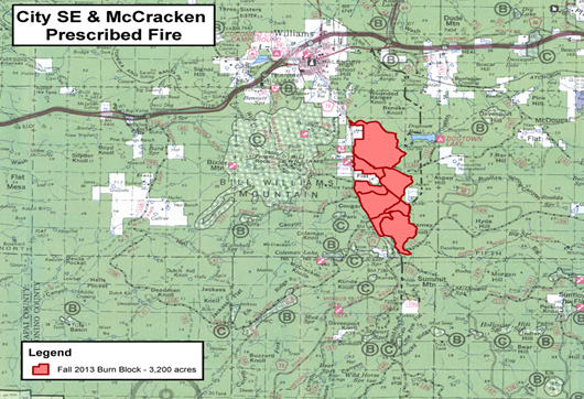
Williams, AZ – Due to favorable conditions, fire managers may implement prescribed fire as soon as Monday September 30, 2013 in the City SE and McCracken East project areas 4 miles southeast of Williams, AZ along County Road 73. At approximately 3200 acres, the burn will be the largest single prescribed burn of the fall on the Williams Ranger District. All prescribed fire activity is dependent on regional Forest Service approval, personnel availability, weather – including winds and ventilation, and approval from the ADEQ www.azdeq.gov.
While smoke production will likely be significant, managers hope to limit impact by conducting all burning operations over a 4 to 5 day time period. “Smoke is a trade-off for having a healthy forest in a fire adapted ecosystem” said Fire Information Officer, Holly Krake. “By reaching out to thousands of people in our local communities, we hope to give as much advance notice as possible and minimize negative smoke impacts”.
Daytime smoke is predicted to generally disperse to the northeast. Overnight smoke may settle with some impact to Williams, Sycamore Canyon, the Verde Valley, and surrounding areas. A smoke column will be highly visible from Williams and adjacent portions of I-40. Additional resources regarding smoke and air quality are available at wildfire.az.gov .
Get fire activity updates 24 hours-a-day:
Fire Information Line at 928-635-8311 Inciweb at inciweb.nwcg.gov Twitter at www.twitter.com/KaibabNF
For additional information, please call Holly Krake (USFS), Fire Information Officer, 928-635-5653
-USFS-
Map of the City SE and McCracken East project areas located 4 miles south of Williams, AZ along County Road 73.
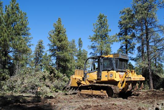
Dozer Operator, Lee Payne, continues prep work ahead of the burn in the McCracken East project area south of Williams, AZ along County Road 73.
This electronic message contains information generated by the USDA solely for the intended recipients. Any unauthorized interception of this message or the use or disclosure of the information it contains may violate the law and subject the violator to civil or criminal penalties. If you believe you have received this message in error, please notify the sender and delete the email immediately. |


Attachment:
1650-1_d1_WRD_Rx_CitySEMcCrackenE_2013_0925.pdf
Description: 1650-1_d1_WRD_Rx_CitySEMcCrackenE_2013_0925.pdf
