|
Prescribed fires are planned in four project locations next week near Jacob Lake on the North Kaibab Ranger District of the Kaibab National Forest. Please see the attached news release for details.
Thank you, Jackie
North Zone fire managers to conduct prescribed fires throughout next week
Fredonia, Ariz., Nov. 8, 2018 —
North Zone fire managers plan to begin prescribed fire operations on Monday and continue through all of next week on up to 3,000 acres on the North Kaibab Ranger
District of the Kaibab National Forest, depending on weather conditions, fuel moisture and smoke dispersal on any given day. Specifically, fire managers plan to treat acres in the following four project locations through the week in order to improve forest
health and reduce the risk of unnaturally severe wildfire:
Because of the proximity of the planned prescribed fires to local roadways and populated areas, fire managers look for specific weather,
fuel and wind conditions under which to ignite within various project locations. Fire managers recognize the negative effects that smoke can have during and immediately after a prescribed fire and are constantly adjusting tactics to minimize impacts.
Despite mitigation efforts, smoke from these planned prescribed fires may still impact or be visible from highways 89A and 67 as well
as the Jacob Lake area. During and for several days following ignition, motorists are cautioned that smoke may be present on roadways for short periods of time. Smoke may also pool in low-lying areas during overnight and early morning hours. Motorists are
reminded to use caution, drive slowly, turn on headlights, and avoid stopping in areas where fire crews are working. The Kaibab National Forest is part of a fire-adapted ecosystem and is dependent on fire to play a natural role in maintaining vibrant
forest health. Objectives for these North Zone prescribed burns include maintaining the natural role of fire in a fire-adapted ecosystem, reducing hazardous fuels accumulations, creating defensible space around structures in developed areas, protecting sensitive
cultural and natural resources, thinning dense stands of trees where appropriate, and stimulating aspen regeneration. The public can view approved prescribed fires for any given day on the Arizona Department of Environmental Quality’s website at
https://azdeq.gov/SmokeManagemet. Prescribed fires on the Kaibab National Forest begin with the forest’s designator “KNF.” To learn more about
smoke and public health, visit http://bit.ly/SmokeHealthAwareness.
Notifications of upcoming prescribed fire projects are provided regularly throughout the year. Additional information can also be obtained
through the following sources:
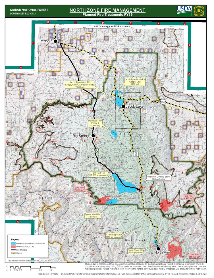
A vicinity map of the various prescribed fire projects planned in 2019 for the North Kaibab Ranger District of the Kaibab National Forest
and the North Rim of the Grand Canyon National is provided below.
This electronic message contains information generated by the USDA solely for the intended recipients. Any unauthorized interception of this message or the use or disclosure of the information it contains may violate the law and subject the violator to civil or criminal penalties. If you believe you have received this message in error, please notify the sender and delete the email immediately. To manage your subscription visit http://www.fs.fed.us/news/subscription.shtml |

Attachment:
1650-1_so_NKRDRxFires_2018_1108_listserv.pdf
Description: 1650-1_so_NKRDRxFires_2018_1108_listserv.pdf
