|
Lightning-caused fires continue to help remove forest debris across Coconino National Forest FLAGSTAFF, Ariz., July 30, 2018, For Immediate Release –
Fire managers with the Coconino National Forest continue monitoring and utilizing several lightning-caused fires to benefit the landscape and maintain a healthy ecosystem
by allowing fire to fulfill its natural role and consume forest debris. Information and details about the Seep, Bristow, Platypus and Deer Fires, including their objectives, will be updated on Inciweb under
the name of the fire at http://inciweb.nwcg.gov/. Quick updates will also be provided via the Forest’s social media sites, to include Twitter at
www.twitter.com/coconinonf (@CoconinoNF) and Facebook at
www.facebook.com/CoconinoNF (@CoconinoNF). These fires, as with any wildfire, do not have planned end dates, but firefighters determine a specific planning area within which the
fire may run its natural course. However, this does not mean the fire will move across the entire planning area, as specific edges of a fire may be suppressed to protect certain values such as public safety, private property, cultural sites, major transmission
power lines, trailheads, dispersed camping sites, and more. Thunderstorms building in the area of the fires may randomly change wind directions making smoke patterns very difficult to predict.
Additionally, monsoon weather and precipitation may extinguish any of these wildfires at any time, which would bring the fire to a conclusion. 1. SEEP FIRE OVERVIEW (https://inciweb.nwcg.gov/incident/6011/)
Discovery date: July
17, 2018 Cause: Lightning. Location: Approximately
3 miles north of Kendrick Park, east of state Route 180 along Forest Roads 523 and 9001E. (Lat/Long:
35.463500, -111.752889) Current size: 2,300
acres and expected to increase. Current resources: Up
to 25 firefighters are assigned which includes overhead. Predicted smoke impacts:
Light to moderate smoke is expected to lift and move to the southwest. Expect changes along U.S. Highway 180 and possibly U.S. Highway 89 over the next several days as monsoon activity unpredictably changes the wind direction. Current closures: None. Recent and current operations:
Fire activity has increased with drying conditions and firefighter ignitions. The fire is burning primarily in grass and juniper vegetation with heavy dead and down debris from the 1996 Horseshoe Fire. Firefighters are using ignitions
to clean up unburned pockets of fuels within the interior of the planning area. The planned action is to utilize existing road system for containment within the 5,000-acre management area. 2. PLATYPUS FIRE OVERVIEW Discovery date: July
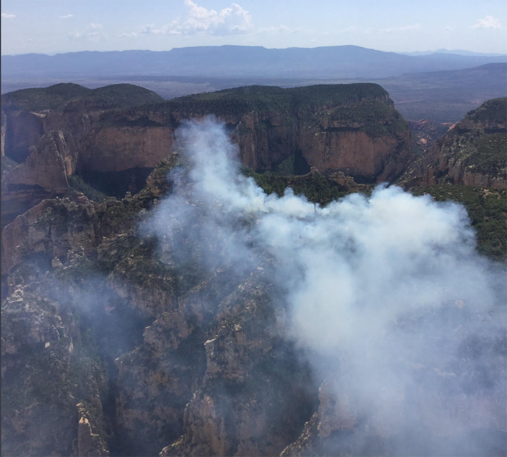
28, 2018. Cause: Lightning. Location: Approximately
4 miles northwest of Sedona in Red Rock Secret Mountain Wilderness more than 6 miles from the nearest trailhead. (Lat/Long:
34.94291, -111.8701) Current size: 9 acres.
Fire modeling indicates the fire is unlikely to grow large in size or pose a significant risk to communities or natural resources. Resources: Lookouts
and aircraft periodically monitor the fire as it’s needed because of the inaccessible to firefighters over the steep and rocky terrain. Predicted smoke impacts:
Smoke is visible from Sedona and the Verde Valley. Current closures: None.
Recent and current operations:
This fire is being monitored because it is in an extremely rugged area of the Red Rock Secret Mountain Wilderness at the edge of sheer cliffs. Any firefighter working in the area would be placed at significant risk, particularly if an injury required rapid
transportation for medical care. Any suppression actions will only be taken if the fire spreads into areas of concern. 3. BRISTOW FIRE OVERVIEW (https://inciweb.nwcg.gov/incident/6010/)
Discovery date: July
20, 2018. Cause: Lightning. Location: Approximately
6 miles southeast of Munds Park and east of Interstate17. (Lat/Long:
34.863611, -111.598500) Current size: 915 acres.
Current resources: Resources
were reduced to three engines and miscellaneous overhead totaling 15 firefighters remaining on the Bristow fire.
Predicted smoke Impacts:
The Bristow Fire continues to burn within its planned containment lines. Given recent moisture on the fire, smoke is light with some impacts along I-17 near Munds Park, especially in the
early morning hours. Both Arizona Department of Transportation and
Coconino National Forest continue to monitor conditions near Rocky Park and Fox Ranch Road exits.
Current closures: None.
Recent and current operations: Crews continue to monitor the Bristow Fire for growth and smoke impacts along I-17 in coordination
with ADOT. Fire managers are anticipating ignitions will resume in a few days.
4. DEER FIRE OVERVIEW (https://inciweb.nwcg.gov/incident/6012/)
Discovery date: July
13, 2018. Cause: Lightning. Location: Approximately
8 miles southwest of C.C. Cragin Reservoir and 3 miles northeast of Kehl Springs Campground. (Lat/Long:
34.471194, -111.290111) Current size: 800 acres.
Once the planning area dries out this wildfire is expected to increase up to 1,800 acres before consuming its fuels. Resources: One engine
and overhead personnel are continuing to monitor this fire until ignition operations can resume. Predicted smoke impacts:
Smoke impacts from this wildfire may include C.C. Cragin Reservoir, Blue Ridge communities and the Blue Ridge Ranger Station. Overnight drainage of the smoke may impact the Strawberry, Pine and Verde Valley areas. Current closures: None.
Recent and current operations:
The Deer Fire is being patrolled and monitored by firefighters.
### This electronic message contains information generated by the USDA solely for the intended recipients. Any unauthorized interception of this message or the use or disclosure of the information it contains may violate the law and subject the violator to civil or criminal penalties. If you believe you have received this message in error, please notify the sender and delete the email immediately. To manage your subscription visit http://www.fs.fed.us/news/subscription.shtml |
Attachment:
COC-NR-7-30-18-ManagedFires.pdf
Description: COC-NR-7-30-18-ManagedFires.pdf
Attachment:
PlatypusFire.jpg
Description: PlatypusFire.jpg
