|
Kaibab National Forest Grand Canyon National Park
For Immediate Release Contact: USFS, Ward Ward, 928-308-0797 July 28, 2014 Contact: NPS, Traci Weaver,
928-638-7065
Greater Grand Canyon Area Fires Update 07.28.14 WILLIAMS, Ariz. – With the return of monsoonal precipitation to all fires, growth and activity have slowed. Crews continue to monitor
the fires and do preparation work ahead of drier conditions forecasted to return mid-week. Smoke will be much lighter today and tonight. Fire managers continue to coordinate with neighboring forests, national parks, municipal fire departments, and the Arizona
Department of Environmental Quality to monitor smoke impacts. For more information on smoke and air quality please visit
www.azdeq.gov
or wildlandfire.az.gov.
Williams Ranger District:
Currently 4040 acres in size, the Sitgreaves Complex is located approximately 5 miles northwest of Parks, Ariz. Crews will monitor the fire and continue preparation work within the planning for future managed ignitions. Smoke will continue to shift as monsoonal
winds vary. Tusayan Ranger District:
Currently 3486 acres in size, the McRae Fire is located approximately 5 miles southeast of Tusayan, Ariz. Today crews will continue preparation for future ignitions within the planning area. Smoke may become highly visible from Highway 64. North Kaibab Ranger District:
Currently 331 acres in size, the Quaking Fire is located approximately 40 miles southeast of Fredonia, Ariz. Today crews will continue to monitor the fire and initiate managed ignitions on FSR 271 as weather allows. Smoke is visible from the Rainbow Rim Trailhead
and Highway 67. North Rim Grand Canyon:
Currently 303 acres in size, the Kanabownits Fire is located approximately 1 mile northeast of the historic Kanabownits Cabin on the Walla Valley Peninsula. Today crews are continuing to monitor the fire and do preparation work. Smoke is visible from the Rainbow
Rim Trailhead and Highway 67. Get fire activity updates and maps 24 hours-a-day: Fire Information Line: 928-635-8311 (USFS) or 928-638-7819 (NPS) Inciweb:
inciweb.nwcg.gov Text Message: text ‘follow kaibabnf’ to 40404 (USFS) or
@GrandCanyonNPS on Twitter (NPS)
-USFS/NPS-
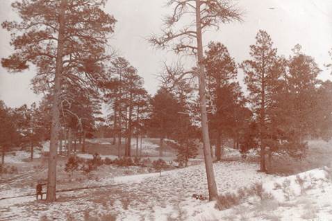
Historic photo from 1906 near the Twin Tanks area off FSR 74 showing mature
tree densities of 20-50 trees per acre. Current mature tree densities are estimated at
1,000-1,500 trees per acre leading to increased threat of high intensity wildfires.
(Photo credit: USFS)
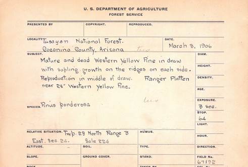
Documentation on reverse side of historic 1906 photograph shown above.
Holly Krake, MSEd Fire Information Officer USDA Forest Service Kaibab National Forest- South Zone 742 S. Clover Road Williams, AZ 86046 p. 928-635-5653 f. 928-635-5680
This electronic message contains information generated by the USDA solely for the intended recipients. Any unauthorized interception of this message or the use or disclosure of the information it contains may violate the law and subject the violator to civil or criminal penalties. If you believe you have received this message in error, please notify the sender and delete the email immediately. |


Attachment:
1650-1_so_McRae_SitgreavesComplex_Quaking_Kanabownits_Fires_2014_0728.pdf
Description: 1650-1_so_McRae_SitgreavesComplex_Quaking_Kanabownits_Fires_2014_0728.pdf
