|
Kaibab National Forest Grand Canyon National Park
For Immediate Release Contact: USFS, Holly Krake, 928-635-5653 July 27, 2014 Contact: NPS, Traci Weaver,
928-638-7065
Greater Grand Canyon Area Fires Update 07.27.14 WILLIAMS, Ariz. – Growth continued yesterday on all fires being managed for resource benefits with multiple objectives. Today crews
continue to do preparation work ahead of managed ignitions and ignitions may occur on some fires. Fire managers continue to coordinate with neighboring forests, national parks, municipal fire departments, and the Arizona Department of Environmental Quality
to monitor smoke impacts. For more information on smoke and air quality please visit
www.azdeq.gov
or wildlandfire.az.gov.
Williams Ranger District:
Currently 3776 acres in size, the Sitgreaves Complex is located approximately 5 miles northwest of Parks, Ariz. Crews completed ignitions along the northern section of FSR 76 within the planning area and continue work along the northern pipeline. Fire growth
is mostly to the west and down slope of the mountain. Tusayan Ranger District:
Currently 3400 acres in size, the McRae Fire is located approximately 5 miles southeast of Tusayan, Ariz. Today crews will continue ignitions within the planning area. Smoke may become highly visible from Highway 64. North Kaibab Ranger District:
Currently 309 acres in size, the Quaking Fire is located approximately 40 miles southeast of Fredonia, Ariz. Today crews will continue ignitions within the planning area. Smoke is visible from the Rainbow Rim Trailhead and Highway 67. North Rim Grand Canyon:
Currently 302 acres in size, the Kanabownits Fire is located approximately 1 mile northeast of the historic Kanabownits Cabin on the Walla Valley Peninsula. Today crews are continuing to monitor the fire and do preparation work. Smoke is visible from the Rainbow
Rim Trailhead and Highway 67. Get fire activity updates and maps 24 hours-a-day: Fire Information Line: 928-635-8311 (USFS) or 928-638-7819 (NPS) Inciweb:
inciweb.nwcg.gov Text Message: text ‘follow kaibabnf’ to 40404 (USFS) or
@GrandCanyonNPS on Twitter (NPS)
-USFS/NPS-
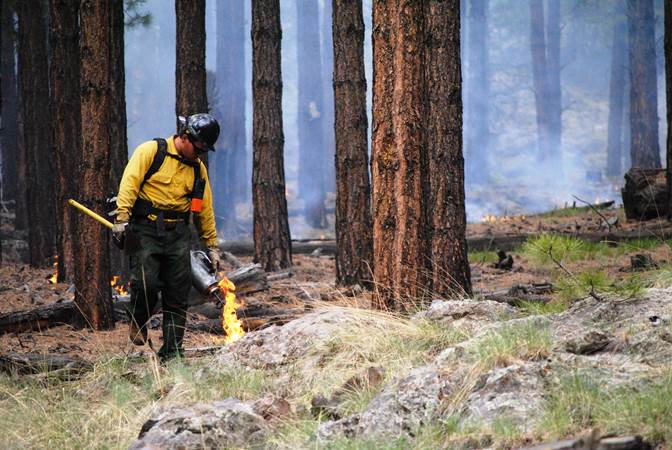
Crews continue managed ignitions along FSR 76 on the Sitgreaves Complex on July 26, 2014.
(Photo credit: USFS/Holly Krake)
Jacqueline C. Banks Public Affairs Officer Kaibab National Forest Office: 928-635-8314 Cell: 928-606-7490 This electronic message contains information generated by the USDA solely for the intended recipients. Any unauthorized interception of this message or the use or disclosure of the information it contains may violate the law and subject the violator to civil or criminal penalties. If you believe you have received this message in error, please notify the sender and delete the email immediately. |


Attachment:
pdf4TW8WCj6hO.pdf
Description: 1650-1_so_McRae_SitgreavesComplex_Quaking_Kanabownits_Fires_2014_0727.pdf
