|
Kaibab National Forest
Website:
www.fs.usda.gov/kaibab
Twitter:
www.twitter.com/KaibabNF Inciweb:
inciweb.nwcg.gov
For Immediate Release Contact: Holly Krake, 928-635-5653
July 21, 2014
Resource Benefit Fires Update 07.21.14 WILLIAMS, AZ – This morning, fire managers combined the Duck and Sitgreaves Fires into the Sitgreaves Complex. A ‘complex’ is generally formed when two or more fires are managed within one
planning area. Variable winds, precipitation, and management tactics can change the amount of smoke produced each day. While varying monsoonal precipitation and winds are likely to change fire behavior and growth over the next several days, general fire behavior
is anticipated to be low to moderate intensity. Williams Ranger District: Currently 1000 acres in size, the Sitgreaves Complex is located approximately
5 miles northwest of Parks, AZ. Today crews may conduct aerial ignitions to continue backing fire down from the ridge tops with low to moderate intensity. Additional hand ignitions may also occur along FSR 76. Crews are reporting good consumption of fuels
throughout the burn area helping to prevent future catastrophic wildfires. Smoke is highly visible from I-40.
A community meeting for the greater Parks, AZ area has been scheduled for Wednesday July 23, 2014 at 5:30pm at the Maine School Gymnasium. Tusayan Ranger District: Currently 2000 acres in size, the McRae Fire is located approximately
5 miles southeast of Tusayan, AZ. Today crews are planning more managed ignitions as needed within the planning area. Smoke may become highly visible from Highway 64. North Kaibab Ranger District: Currently 70 acres in size, the Quaking Fire is located approximately
40 miles southeast of Fredonia, AZ. Today crews are planning managed ignitions as needed along FSRs 271. No smoke impacts are anticipated at this time. Get fire activity updates and maps 24 hours-a-day: Fire Information Line: 928-635-8311 Inciweb:
inciweb.nwcg.gov Text Message: text ‘follow kaibabnf’ to 40404
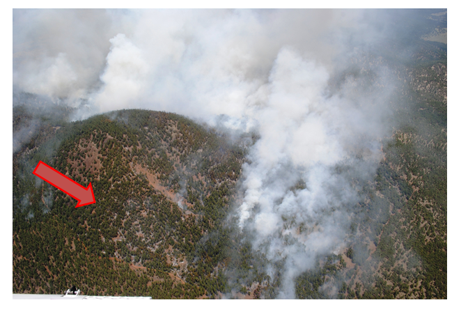
Heavy fuels are consumed, helping to reduce the risk of future catastrophic wildfire,
on the Sitgreaves Complex near Parks, AZ on July 20, 2014. (Photo Credit: USFS/ Holly Krake) Holly Krake, MSEd Fire Information Officer USDA Forest Service Kaibab National Forest- South Zone 742 S. Clover Road Williams, AZ 86046 p. 928-635-5653 f. 928-635-5680
This electronic message contains information generated by the USDA solely for the intended recipients. Any unauthorized interception of this message or the use or disclosure of the information it contains may violate the law and subject the violator to civil or criminal penalties. If you believe you have received this message in error, please notify the sender and delete the email immediately. |


Attachment:
1650-1_so_McRae_SitgreavesComplex_Quaking_Fires_2014_0721.pdf
Description: 1650-1_so_McRae_SitgreavesComplex_Quaking_Fires_2014_0721.pdf
