|
Please see attached news release regarding the fall 2013 Williams and Tusayan Ranger Districts prescribed (Rx) fire plans on the Kaibab National Forest. Individual map files are available at the Kaibab NF website www.fs.usda.gov/kaibab.
Thank you,
Holly Krake, MSEd Fire Information Officer USDA Forest Service Kaibab National Forest- South Zone 742 S. Clover Road Williams, AZ 86046 p. 928-635-5653 f. 928-635-5680
Kaibab National Forest
Website: www.fs.usda.gov/kaibab Twitter: www.twitter.com/KaibabNF Wildfire Information: Inciweb.org
For Immediate Release Contact: Holly Krake, 928-635-5653 August 22, 2013
South Zone Releases Fall 2013 Prescribed Fire Plans
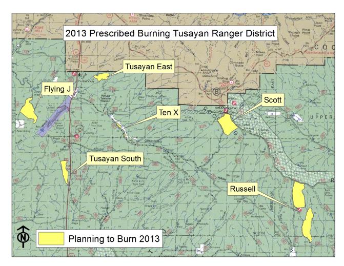
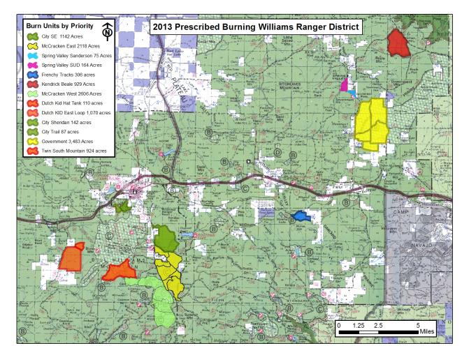
WILLIAMS, AZ – This year, the Williams and Tusayan Ranger Districts have prescribed (Rx) fire plans for approximately 13,000 acres and 5,000 acres respectively. However, these numbers represent planned maximums while actual acres burned may be significantly less. Starting in early September, fire managers will use prescribed fire as part of continuing efforts to improve forest health, enhance public safety, and return fire to a fire-adapted ecosystem. While Rx fire lowers the risk of severe wildfires on the forest, there may be noticeable impacts, such as smoke production.
Before a Rx fire, notification will be provided through multiple channels including; email news releases, Forest fire information line, Inciweb, Twitter, flyers, and the Forest website. Fire information boards, public advisories, and large signage will also be placed in the immediate fire management area.
During a Rx fire, firefighter activity, helicopter noise, and smoke can all have a significant impact. Fire managers hope to minimize any inconvenience through careful planning and coordination. “We work closely with the National Weather Service and the Arizona Department of Environmental Quality before and during prescribed burns to get things right and minimize impacts” said Fire Management Officer, James Pettit. “A critical goal is to be good neighbors to our communities and adjacent landowners”. Conditions include correct temperature, wind, fuel moisture, ventilation, and relative humidity. When these criteria are met, crews implement, monitor, and patrol each burn to ensure it meets the goals and objectives outlined by managers.
Immediately following a Rx fire, browning of lower level pine needles may occur as the tree crown is raised. This is perfectly normal and healthy. Some areas are also part of long term project work where future timber marking paint, mechanical thinning equipment, and other impacts may occur.
For additional Rx fire maps, photos, and information on active incidents, please visit inciweb.org or call Holly Krake (USFS), Fire Information Officer, 928-635-5653
-USFS-
Image 1: Tusayan Ranger District Fall 2013 Rx Fire Planning Map.
Table 1: Project name, acres, and location description for Tusayan Ranger District Fall 2013 Rx Fire.
Image 2: Williams Ranger District Fall 2013 Rx Fire Planning Map.
Table 2: Project name, acres, and location description for Williams Ranger District Fall 2013 Rx Fire.
This electronic message contains information generated by the USDA solely for the intended recipients. Any unauthorized interception of this message or the use or disclosure of the information it contains may violate the law and subject the violator to civil or criminal penalties. If you believe you have received this message in error, please notify the sender and delete the email immediately. |


Attachment:
1650-1_so_Southzone_Rx_Fire_Plans_2013_0822v2.pdf
Description: 1650-1_so_Southzone_Rx_Fire_Plans_2013_0822v2.pdf
