|
Please see attached news release update regarding the Mud Fire on the Williams Ranger District near Williams, AZ on the Kaibab National Forest.
Thank you,
Holly Krake, MSEd Fire Information Officer USDA Forest Service Kaibab National Forest- South Zone 742 S. Clover Road Williams, AZ 86046 p. 928-635-5653 f. 928-635-5680
Kaibab National ForestWebsite: www.fs.usda.gov/kaibab Twitter: www.twitter.com/KaibabNF Wildfire Information: Inciweb.org
For Immediate Release Contact: Holly Krake, 928-635-5653August 13, 2013Mud Fire Growing with Recent Drying Trends
WILLIAMS, AZ – Over the past several days, fire managers have seen steady growth on the Mud Fire to its current size of 75 acres. The fire continues to move predominately to the south along Rocky Ridge near Summit Mountain south of Williams. Recent and forecasted drying trends should contribute to potential fire spread within the 7,700 acre planning area. Assistant Fire Management Officer, Mike Uebel, cautions “planning areas are the maximum perimeters a resource fire could grow to given perfect conditions. It is truly a maximum, not a goal”. Crews are continually monitoring this naturally spreading fire for changes in behavior and growth as drying trends extend. The Mud Fire planning area was developed with resource benefit to multiple objectives including maintaining a fire-adapted ecosystem and protecting cultural resources and wildlife habitat.
Date/Time Reported: Monday July 29th, 2013 Location: 10 miles south of Williams Cause: Lightning Size: 75 Acres Landscape/Fuels: Ponderosa Pine and Oak Fire Behavior: Low intensity creeping and smoldering Planning Area: 7,700 acres
Smoke impacts should continue to be minimal to the Williams community. However, varying monsoonal precipitation and winds may change fire behavior and growth resulting in increased smoke production. Hunters scouting for fall hunts and general forest visitors are asked to use caution in the general fire area and observe all posted signs.
For additional information, please call Holly Krake (USFS), Fire Information Officer, 928-635-5653
-USFS-
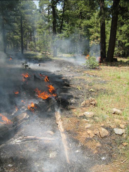
Low intensity fire behavior as seen on the Mud Fire on the afternoon of August 12th, 2013 approximately 10 miles south of Williams, AZ.
This electronic message contains information generated by the USDA solely for the intended recipients. Any unauthorized interception of this message or the use or disclosure of the information it contains may violate the law and subject the violator to civil or criminal penalties. If you believe you have received this message in error, please notify the sender and delete the email immediately. |


Attachment:
1650-1_d1_Mud_Fire_2013_0813.pdf
Description: 1650-1_d1_Mud_Fire_2013_0813.pdf
