|
Good morning, Please see attached news release regarding Kaibab National Forest efforts to expand LiDAR data coverage in Arizona and bring together partners in this work. Thank you,
Kaibab National Forest leads partner effort to bring critical geographic data to Arizona
Williams, Ariz., Sept. 17, 2018—For Immediate Release. Employees with the Kaibab National Forest led the recent effort to unify a diverse group of partners for the
first-ever Arizona LiDAR symposium, which was held Aug. 15 in Flagstaff. Organizers strived and succeeded in bringing together government agencies, nonprofits, universities and other organizations to begin to collaboratively fund the collection of this critical
geographic data and guide its ultimate use in projects and partnerships statewide.
LiDAR, which stands for Light Detection and Ranging, is a remote sensing method used to examine the surface of the Earth. Specifically, it uses light in the form of a pulsed laser to measure variable distances to the
Earth. These light pulses, combined with other data recorded by the airborne system, generate precise, three-dimensional information about the shape of the planet and its surface characteristics.
This highly accurate elevation data allows scientists and mapping professionals to examine both natural and man-made environments with precision and flexibility. Specialists can use this data to measure everything from
trees and agricultural fields to buildings and transportation systems. Within the Forest Service, LiDAR data allows specialists to map roads and streams, model wildlife habitats, and chart the impact of fire on the landscape, as examples.
“LiDAR is base data that can help almost every aspect of forest operations as well as programs and projects across Arizona because it provides a complete picture of the landscape,” said Mark Christiano, GIS coordinator
for the Kaibab National Forest and one of the lead organizers of the LiDAR symposium. “Ultimately, LiDAR can save lives. This data is critical in planning for natural disasters, such as wildfires and floods, and in creating better maps for search and rescue
and other emergency response operations. It has a huge range of applications, making it a critical resource for many agencies and organizations, including the Forest Service.”
Currently, there is little LiDAR data available in the state of Arizona. To address this issue, the Arizona Geographic Information Council created a work group focused on the goal of facilitating the collection of LiDAR.
It was as part of this work group that Christiano, along with Jenna Straface, senior GIS analyst for the Arizona State Land Department, developed the concept of hosting a symposium to bring together potential partners interested in this valuable geographic
data.
More than 60 attendees participated in the August LiDAR symposium, representing federal, state and local government agencies; nonprofits; universities; research organizations; and, private corporations. A cadre of LiDAR
experts provided information on everything from the basics of what LiDAR is and its many applications to more complex topics such as specific industry uses and best practices in LiDAR acquisition. The symposium, which was held at Northern Arizona University,
also gave participants the opportunity to network with other industries and organizations and strategize about future partnerships.
“Partnerships and collaborative projects are a win-win in my book, adding weight to the old saying that two heads are better than one,” said Dr. Andrew Sánchez Meador, a professor at Northern Arizona University and a
guest speaker at the LiDAR symposium. “It’s been my experience that science and practice are enriched by collaboration among individuals with diverse but complementary perspectives, needs, and backgrounds – allowing us a fresh perspective on the problem and
adding unanticipated value to the project.”
Opportunities such as the recent symposium help in achieving the objectives of statewide LiDAR coverage and the creation of educational platforms that increase public and industry knowledge of LiDAR. According to Christiano,
those objectives are well aligned with the Forest Service strategic goals of applying knowledge globally, delivering benefits to the public, and sustaining the nation’s forests and grasslands.
In order to achieve those goals and take advantage of the many benefits of this advanced technology, the Kaibab National Forest has focused on acquiring LiDAR data and has recently achieved coverage of about 1.26 million
acres of the forest’s 1.6 million acres, which specialists believe will help better sustain and manage these public lands. Ultimately, managers want a high-quality, forestwide LiDAR dataset to support all aspects of forest management by providing detailed
surface and vegetation structure information for use in assessments, effects analyses, modeling and monitoring.
“Land managers are being asked to assess current condition, evaluate and compare treatment outcomes, and monitor the success or failure of treatments at increased spatial scales and usually with reduced resources,” said
Sánchez Meador. “LiDAR can provide accurate information about these forests, in three dimensions and over vast areas, thus delivering the detailed and scalable information necessary for the planning and management of our forest resources.”
Due to the success of the first-ever Arizona LiDAR symposium, coordinators plan to host the event annually in order to facilitate networking of interested stakeholders, explore uses of the data, and highlight projects
around the state. Sponsors of this year’s event were the Forest Service, Northern Arizona University’s School of Forestry and Ecological Restoration Institute, The Nature Conservancy, and the remote sensing and surveying company Atlantic.
“This is the beginning of a great, statewide partnership that we can use to overcome communication barriers,” Christiano said. “I’m looking forward to seeing the LiDAR symposium become a nexus of education and a platform
for groups to showcase their LiDAR partnerships and projects.”
Visit https://gis.azgeo.az.gov/agic/welcome-agic to learn more about the Arizona Geographic
Information Council. Those interested in joining the AGIC LiDAR work group may contact Jenna Straface at
jstraface@xxxxxxxxxx.
Kaibab National Forest information is available through the following sources:
A graphic of the LiDAR symposium logo. The event was held Aug. 15 at Northern Arizona University. Graphic by Adriana Petrungaro, Kaibab National Forest.
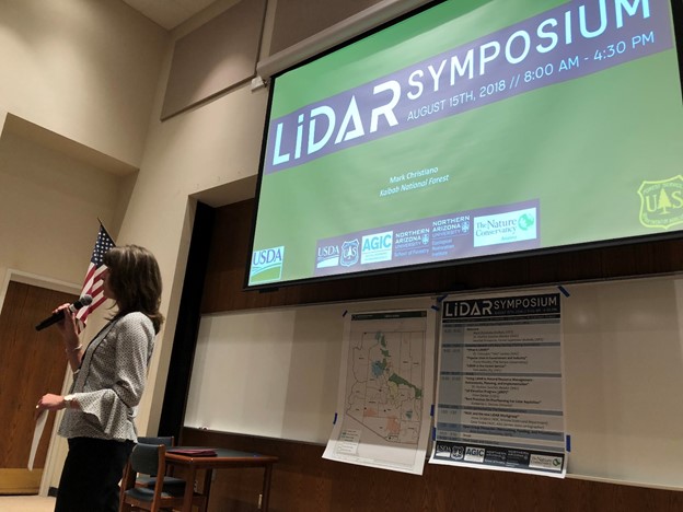
Kaibab National Forest Supervisor Heather Provencio provides welcome remarks at the first-ever Arizona LiDAR symposium. Photo by Mark Christiano. Credit Kaibab National Forest. This electronic message contains information generated by the USDA solely for the intended recipients. Any unauthorized interception of this message or the use or disclosure of the information it contains may violate the law and subject the violator to civil or criminal penalties. If you believe you have received this message in error, please notify the sender and delete the email immediately. To manage your subscription visit http://www.fs.fed.us/news/subscription.shtml |


Attachment:
1650-1_so_LiDARSymposium_2018_0917.pdf
Description: 1650-1_so_LiDARSymposium_2018_0917.pdf
