|
Fire managers for the South Zone of the Kaibab National Forest plan to treat up to 320 acres with prescribed fire tomorrow in the Sunflower Project area on the Williams Ranger District. No other prescribed fire projects are planned for
the Williams Ranger District this week. Thank you,
Fire managers to conduct prescribed fire southeast of Williams tomorrow
Williams, Ariz., Nov. 27, 2017 — For Immediate Release. Fire managers for the South Zone of the Kaibab National Forest plan to treat
up to 320 acres with prescribed fire tomorrow in the Sunflower Project area on the Williams Ranger District.
Specifically, fire managers plan to ignite the 320 acres in an area just south of Forest Road 139 and east of Hyde Hill about 8 miles southeast of the City of Williams. Ignitions should be complete by
early afternoon, and fire managers do not anticipate conducting any other prescribed fires on the Williams Ranger District this week.
Smoke from tomorrow’s prescribed fire in the Sunflower Project area is expected to largely remain south of Williams and potentially impact Barney Flat and Cougar Park. It is possible that light smoke
impacts may occur along County Road 73 and in Williams.
Prescribed fire projects require approval from the Arizona Department of Environmental Quality and are dependent on weather and wind conditions, so any project may be canceled if approval is not received
or if conditions are not suitable. Members of the public can view approved prescribed fires for any given day on ADEQ’s website at
http://www.azdeq.gov/environ/air/smoke/index.html.
Prescribed fires on the Kaibab National Forest begin with the identifier “KNF.”
Fire plays a beneficial role in maintaining the ecological stability of many landscapes including the Kaibab National Forest. Managers use prescribed fire to reduce risks associated with uncharacteristic
wildfires that can pose significant threats to public health and safety.
During prescribed fires, motorists are cautioned that smoke may be present for short durations, which may impact roads and populated areas. Motorists are reminded to use caution, drive slowly, turn on
headlights, and avoid stopping in areas where fire personnel are working.
Notifications of upcoming prescribed fires are provided regularly by news releases throughout the season and also through the following resources:
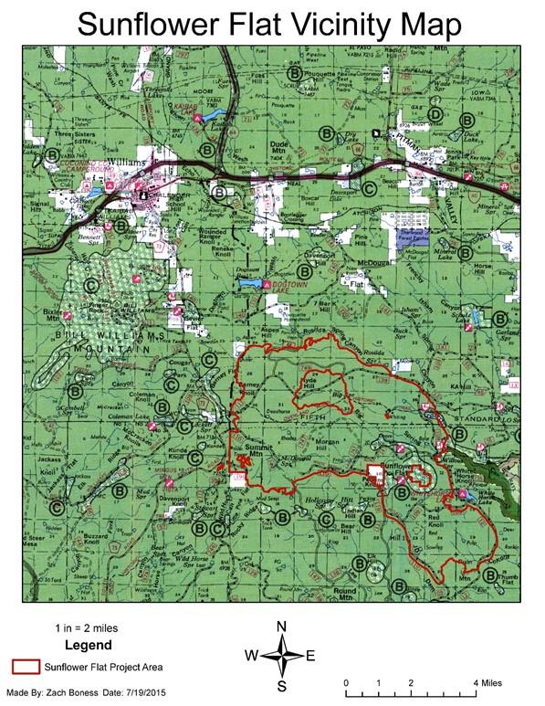
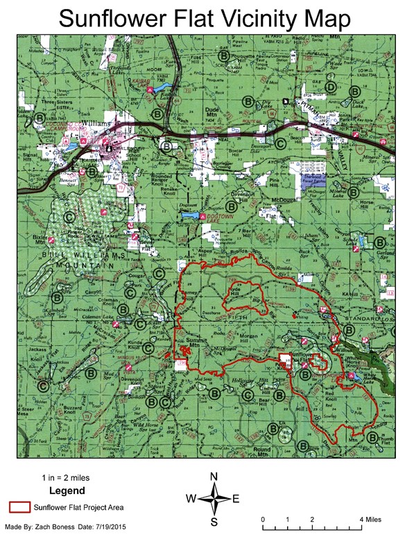
A map of the Sunflower Project area is provided below. The map shows the entire 15,195-acre Sunflower Project. Tomorrow, fire managers plan to burn only 320 acres in the northeast corner of the larger
project area just south of Forest Road 139 and east of Hyde Hill.
###
NOTE: This map shows the entire 15,195-acre Sunflower Project. Tomorrow, fire managers plan to burn only 320 acres in the northeast corner of the larger project area just south of Forest Road 139 and east
of Hyde Hill. This electronic message contains information generated by the USDA solely for the intended recipients. Any unauthorized interception of this message or the use or disclosure of the information it contains may violate the law and subject the violator to civil or criminal penalties. If you believe you have received this message in error, please notify the sender and delete the email immediately. To manage your subscription visit http://www.fs.fed.us/news/subscription.shtml |
Attachment:
1650-1_d1_SunflowerRX_2017_1127.pdf
Description: 1650-1_d1_SunflowerRX_2017_1127.pdf


