|
Kaibab National Forest
Website:
www.fs.usda.gov/kaibab Twitter:
www.twitter.com/KaibabNF Inciweb:
inciweb.nwcg.gov
For Immediate Release Contact: Holly Krake, 928-635-5653 July 23, 2014
Resource Benefit Fires Update 07.23.14 WILLIAMS, AZ –Today crews will again continue active managed ignitions on all three fires across the forest. These ignitions are
to strengthen existing road perimeters and keep fire progressing within the planning areas. Smoke impacts will continue to vary each day. For more information on smoke and air quality please visit
www.azdeq.gov
or wildlandfire.az.gov. Williams Ranger District:
Currently 1960 acres in size, the Sitgreaves Complex is located approximately 5 miles northwest of Parks, AZ. Fire continues to move down slope and to the west. Aerial ignitions may continue along the north side of the mountain as needed. Some moderate fire
intensity, including tree torching, is helping to reduce tree density and improve openings for future Aspen regeneration.
A community meeting for the greater Parks, AZ area has been scheduled for Wednesday July 23, 2014 at 5:30pm at the Maine School Gymnasium.
A closure order has also been placed for the northern section of the planning area for firefighter and public safety.
Tusayan Ranger District:
Currently 2700 acres in size, the McRae Fire is located approximately 5 miles southeast of Tusayan, AZ. Yesterday as a wind shift moved smoke towards the town of Tusayan, crews stopped all ignitions. Today crews are planning more managed ignitions as needed
within the planning area. Smoke may become highly visible from Highway 64. North Kaibab Ranger District:
Currently 112 acres in size, the Quaking Fire is located approximately 40 miles southeast of Fredonia, AZ. Today crews are planning managed ignitions as needed along FSRs 271. Smoke is visible from the Rainbow Rim Trailhead and Highway 67. Get fire activity updates and maps 24 hours-a-day: Fire Information Line: 928-635-8311 Inciweb:
inciweb.nwcg.gov Text Message: text ‘follow kaibabnf’ to 40404
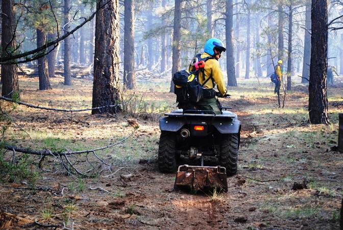
Firefighters put in drag and hand line in preperation for future firing operations
on the Sitgreaves Complex near Parks, AZ. (Photo Credit: USFS/ Holly Krake) Holly Krake, MSEd Fire Information Officer USDA Forest Service Kaibab National Forest- South Zone 742 S. Clover Road Williams, AZ 86046 p. 928-635-5653 f. 928-635-5680
This electronic message contains information generated by the USDA solely for the intended recipients. Any unauthorized interception of this message or the use or disclosure of the information it contains may violate the law and subject the violator to civil or criminal penalties. If you believe you have received this message in error, please notify the sender and delete the email immediately. |


Attachment:
1650-1_so_McRae_SitgreavesComplex_Quaking_Fires_2014_0723.pdf
Description: 1650-1_so_McRae_SitgreavesComplex_Quaking_Fires_2014_0723.pdf
Attachment:
Sitgreaves_Complex_Closure_Order_2014_0723.pdf
Description: Sitgreaves_Complex_Closure_Order_2014_0723.pdf
