|
Kaibab National Forest
Website:
www.fs.usda.gov/kaibab
Twitter:
www.twitter.com/KaibabNF Inciweb:
inciweb.nwcg.gov
For Immediate Release Contact: Holly Krake, 928-635-5653
July 18, 2014
Resource Benefit Fires Update 07.18.14 WILLIAMS, AZ – Due to growth on the Duck and Sitgreaves Fires, more resources, including two fire crews have arrived and are actively working the fires. Crews anticipate conducting managed
ignitions along FSR 76 as needed. Variable winds, precipitation, and management tactics can change the amount of visible smoke each day. While varying monsoonal precipitation and winds are likely to change fire behavior and growth over the next several days,
general fire behavior is anticipated to be low to moderate intensity. Williams Ranger District: Currently 40 acres in size, the Sitgreaves Fire is located approximately
5 miles northwest of Parks, AZ. Today fire will continue to back down the western and southern slopes as it burns through forest pine litter. To plan for fire growth, officials have identified a specific planning area of approximately 14,800 acres in which
the fire could spread. Smoke may be highly visible from I-40. Currently 188 acres in size, the Duck Fire is located approximately 3 miles northwest of Parks, AZ. Fire growth has become more active due to drier conditions.
Smoke is highly visible from I-40. Tusayan Ranger District: Currently 625 acres in size, the McRae Fire is located approximately 5
miles southeast of Tusayan, AZ. To plan for fire growth, officials have identified a specific planning area of approximately 11,000 acres in which the fire could spread. Today crews are planning 400 acres of managed ignitions as needed within the planning
area. Smoke may become highly visible from Highway 64. North Kaibab Ranger District: Currently 6 acres in size, the Quaking Fire is located approximately
76 miles southeast of Fredonia, AZ. To plan for fire growth, officials have identified a specific planning area of approximately 1,100 acres in which the fire could spread. No smoke impacts are anticipated at this time. Get fire activity updates and maps 24 hours-a-day: Fire Information Line: 928-635-8311 Inciweb:
inciweb.nwcg.gov Text Message: text ‘follow kaibabnf’ to 40404
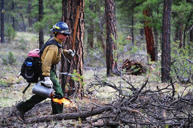
A USFS firefighter conducts managed ignitions on the McRae Fire near
Tusayan, AZ on July 17, 2014. Holly Krake, MSEd Fire Information Officer USDA Forest Service Kaibab National Forest- South Zone 742 S. Clover Road Williams, AZ 86046 p. 928-635-5653 f. 928-635-5680
This electronic message contains information generated by the USDA solely for the intended recipients. Any unauthorized interception of this message or the use or disclosure of the information it contains may violate the law and subject the violator to civil or criminal penalties. If you believe you have received this message in error, please notify the sender and delete the email immediately. |


Attachment:
1650-1_so_McRae_Sitgreaves_Duck_Quaking_Fires_2014_0718.pdf
Description: 1650-1_so_McRae_Sitgreaves_Duck_Quaking_Fires_2014_0718.pdf
