|
Please see attached advisory regarding various prescribed burns planned across the Kaibab National Forest for the week of January 26, 2014. For additional maps, daily updates, and pictures of active burns, please
visit http://inciweb.nwcg.gov/ Holly Krake, MSEd Fire Information Officer USDA Forest Service Kaibab National Forest- South Zone 742 S. Clover Road Williams, AZ 86046 p. 928-635-5653 f. 928-635-5680
Kaibab National Forest
Website:
www.fs.usda.gov/kaibab
Twitter:
www.twitter.com/KaibabNF Inciweb:
inciweb.nwcg.gov
For Immediate Release Contact: Holly Krake, 928-635-5653
January 24, 2014
2,700 Acre Grassland Restoration Prescribed Fire Planned Williams, AZ – As drier conditions continue, fire managers on the Williams and Tusayan Ranger Districts are planning various prescribed fires for the week of January 26, 2014.
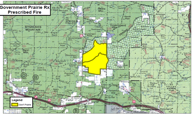
Williams Ranger District: Tentative plans starting as soon as Monday January 27, 2014 in the Government
Prairie project area 8 miles northeast of Parks, AZ. This 2,742 acre burn is designed to enhance grassland restoration and maintenance as well as benefit wildlife on the forest.
While smoke production from this grassland burn will likely be significant, managers hope to limit impact by conducting all burning operations over a 2 to 3 day
time period. Daytime smoke is predicted to dissipate quickly with little to no overnight impacts in surrounding areas. Smoke will be highly visible from Flagstaff, Bellemont, and adjacent portions of I-40. Tusayan Ranger District: Tentative plans for the week of January 26, 2014 include another 200 acres
in the Flying J project area 3 miles southwest of Tusayan, AZ. Alternate tentative plans are for 190 acres in the Tusayan East project located 3 northeast of Tusayan, AZ east of Highway 64.
North Kaibab Ranger District:
No prescribed fires planned at this time.
All prescribed fire activity is dependent on personnel availability, weather – including winds and ventilation, and approval from the ADEQ
www.azdeq.gov. Additional resources regarding smoke and air quality are available at
wildfire.az.gov . Get fire activity updates and maps 24 hours-a-day: Fire Information Line at 928-635-8311 Inciweb at
inciweb.nwcg.gov -USFS-
Map of the Government Prairie Rx project area located 8 miles northeast of Parks, AZ along CR 141.
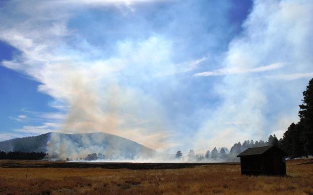
Smoke from grass ignitions on the Spring Valley Rx quickly dissipates in
October 2013 on the Williams Ranger District. This electronic message contains information generated by the USDA solely for the intended recipients. Any unauthorized interception of this message or the use or disclosure of the information it contains may violate the law and subject the violator to civil or criminal penalties. If you believe you have received this message in error, please notify the sender and delete the email immediately. |


Attachment:
1650-1_so_KNF_All_Rx_2014_0124.pdf
Description: 1650-1_so_KNF_All_Rx_2014_0124.pdf
