This release can be found in the USGS Newsroom at: http://www.usgs.gov/newsroom/article.asp?ID=2054.
 
News Release | ||||||||
|
Where is Snæfellsjökull?
Where is Snæfellsjökull?
... and what does it look like? Now you can find out. You can also learn where Eyjafjallajökull, Breiðamerkurjökull, and Þórisjökull are and what they look like. Just maybe, for our non-Icelandic audience, we need to explain. These are not typos. They are just four of the geographic names, gleaned from literature dating back to 13th century Icelandic sagas, for Iceland’s 269 modern named glaciers. Science fiction readers (and movie goers) will quickly identify Snæfellsjökull as the glacier-capped volcano whose summit crater was the entry point in Jules Verne´s Journey to the Center of the Earth. The ice-margin glacial lake, Jökulsárlón, in front of the Breiðamerkurjökull outlet glacier from Iceland´s largest ice cap, was the setting for sequences in two of the James Bond movies.
| Geographic Names
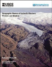
of Iceland’s Glaciers: Historic and Modern provides a wealth of information
about all the named glaciers in
Iceland. It includes descriptions, a striking array of aerial and ground photographs, satellite images, maps, geographic coordinates, and bibliographic citations for the use of all glacier place-names on published maps and in the literature to document each of the 269 modern-named glaciers of Iceland. To produce this book, authors Oddur Sigurðsson of the Hydrological Service of Iceland´s National Energy Authority (NEA) and Richard S. Williams, Jr. of the Woods Hole Science Center of the U.S. Geological Survey (USGS) combed through the long and unique history that Icelanders have been observing their glaciers. According to Sigurðsson, "Some of the glaciers were named more than a millennium ago, although the written record only dates back about eight centuries." For hundreds of years, changes in the glaciers were observed and documented in historic annals by local residents. The first published national record of Icelandic glaciers dates back 300 years. Since 1930, scientists and lay people, under the successive leadership of Jón Eyþórsson, Sigurjón Rist, and Oddur Sigurðsson have made systematic annual measurements of fluctuations in many glaciers in Iceland. Iceland has an impressive array of glaciers for a nation with an area about the size of the Commonwealth of Virginia (40,000 sq. mi. or 103,000 sq. km.). The modern-named glaciers include: 16 ice caps, 109 outlet glaciers, 8 ice-flow basins, 3 ice streams, 55 cirque glaciers, 73 mountain glaciers, and 5 valley glaciers. Iceland also has 21 surge-type glaciers and 38 named snow patches. Geographic Names of Iceland’s Glaciers: Historic and Modern is the second of the three books on Iceland’s glaciers that has been published under the auspices of Iceland’s NEA and the USGS. The three books are a natural progression in the collaborative research to accurately determine the aerial extent of all of the glaciers of Iceland and the response, over time, of its glaciers to changes in climate. The first book, Icelandic Ice Mountains, was published by the Icelandic Literary Society in 2004, in cooperation with the Icelandic Glaciological Society and the International Glaciological Society. ldquo;Iceland’s glaciers are especially sensitive to changes in climate. During the last half of the 20th century, 6 named glaciers disappeared,” said Williams, USGS scientist emeritus who has been studying Iceland’s changing glaciers with Icelandic colleagues for more than four decades. “This book is a story of Iceland’s glaciers, but its compilation is a story of long- term cooperation between the USGS and Iceland’s NEA.” Sigurðsson added that, "Not only climate determines the fate of glaciers in Iceland, a volcanically active nation which is situated on the Mid-Atlantic Ridge. Subglacial volcanic eruptions may melt substantial parts of an ice cap and cause catastrophic ‘glacier outburst floods,’ internationally known as ‘jökulhlaups.’ Some of the historic jökulhlaups have produced the largest floods across glacial outwash plains ("sandur") and glacial rivers ever witnessed by humans. All of these processes are also expressed in many geographic place-names of Iceland." Geographic Names of Iceland’s
Glaciers: Historic and Modern, USGS Professional Paper 1746, is available
in print and online. An Icelandic language edition is planned for the future.
| 
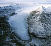
Oblique aerial photograph of the Lambatungnajökull outlet glacier on 1 October 1990. View looking to the northwest toward the eastern margin of the VATNAJÖKULL ice cap. Photograph no. 12045v by O.S., NEA. | 
Oblique aerial photograph of Sólheimajökull, an outlet glacier on the southern margin of MÝRDALSJÖKULL, with black tephra from the 1918 eruption of Katla. View looking toward the northeast on 30 October 1985. The plateau of the Katla caldera is visible in the background. Photograph by Oddur Sigurðsson, National Energy Authority. See figure 171 on p. 181. |
| USGS provides science
for a changing world. For more information, visit www.usgs.gov.
Subscribe to USGS News Releases via our electronic mailing list or RSS feed. **** www.usgs.gov **** Links and contacts within this release are valid at the time of publication.
| ||
