This release can be found in the USGS Newsroom at: http://www.usgs.gov/newsroom/article.asp?ID=2033.

News Release | ||||||||
|
Most Alaskan Glaciers Retreating, Thinning, and Stagnating, Says Major USGS Report
Editors and Reporters: To interview the author during the Geological Society of America meeting, please contact the GSA Newsroom on 1-713-853-8329. Molnia will be presenting a poster (#76-3) at GSA on Wednesday, Oct. 8, from 8 a.m. to noon in Exhibit Hall E.
For high-resolution photos please see this press release at the USGS newsroom site at http://www.usgs.gov/newsroom/
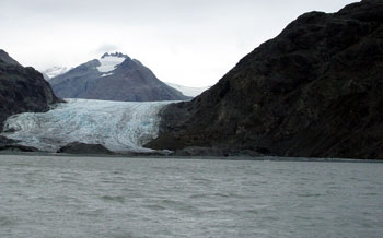
Most glaciers in every mountain range and island group in Alaska are experiencing significant retreat, thinning or stagnation, especially glaciers at lower elevations, according to a new book published by the U.S. Geological Survey. In places, these changes began as early as the middle of the 18th century.
Although more than 99 percent of Alaska's large glaciers are retreating, a handful, surprisingly, are advancing.
The Glaciers of Alaska, authored by USGS research geologist Bruce Molnia, represents a comprehensive overview of the state of the glaciers of Alaska at the end of the 20th century and beginning of the 21st century. Richard Williams Jr., an emeritus senior research glaciologist with the USGS, said the 550-page volume will serve as a major reference work for glaciologists studying glaciers in Alaska in the years and decades to come.
The report uses a combination of satellite images, vertical aerial photographs (black-and-white and color-infrared photos taken from airplanes, looking straight down), oblique aerial photographs (color photos taken from the air at an angle, such as most regular photos), and maps, supported by the scientific literature, to document the distribution and behavior of glaciers throughout Alaska.
The author concludes that, because of the vast areas encompassed by the glacierized regions of Alaska, satellite remote sensing provides the only feasible means of monitoring changes in glacier area and in position of termini -- the end of a glacier -- in response to short- and long-term changes in the marine and continental climates of Alaska.
Alaskan glaciers are found in 11 mountain ranges, one large island, one island chain, and one archipelago. Details about the recent behavior of many of Alaska's glaciers are contained in this richly illustrated book, with multiple photographs and satellite images, as well as hundreds of aerial photographs by Molnia, taken during his more than four decades of work in Alaska.
Three other USGS glaciologists authored two sidebar sections of the book: Columbia and Hubbard Tidewater Glaciers, by Robert M. Krimmel; and The 1986 and 2002 Temporary Closures of Russell Fiord by the Hubbard Glacier, by Bruce F. Molnia, Dennis C. Trabant, Rod S. March, and Robert M. Krimmel. A third section, Geospatial Inventory and Analysis of Glaciers: a Case Study for the Eastern Alaska Range, was authored by William F. Manley, Institute of Arctic and Alpine Research (INSTAAR), University of Colorado.
This professional paper (USGS Professional Paper 1386-K) is available in print and online at http://pubs.usgs.gov/pp/p1386k/. It is the 8th volume to be published in the Satellite Image Atlas of Glaciers of the World series; the other seven volumes are available in print and online at http://pubs.usgs.gov/fs/2005/3056/ More than 100 glaciologists from the United States and other nations have collaborated with the USGS to produce these 11 volumes.
| 
|
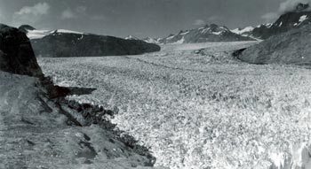
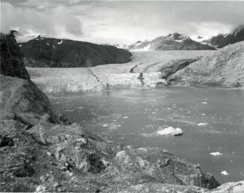
| This August 1941 photograph is of Muir Glacier in Glacier Bay National Monument, Alaska. It shows the lower reaches of Muir Glacier, then a large, tidewater calving valley glacier and its tributary, Riggs Glacier. For nearly two centuries before 1941, Muir Glacier had been retreating. In places, a thickness of more than two-thirds of a mile of ice had been lost. Photo courtesy of the National Snow and Ice Data Center and Glacier Bay National Park and Preserve Archive | This August 1950 photo documents the significant changes that occurred during the 9 years between photographs A and B. Muir Glacier has retreated more than 2 miles, exposing Muir Inlet, and thinned 340 feet or more. However, it still is connected with tributary Riggs Glacier. Photo courtesy of the Glacier Bay National Park and Preserve Archive |
| 
|
|
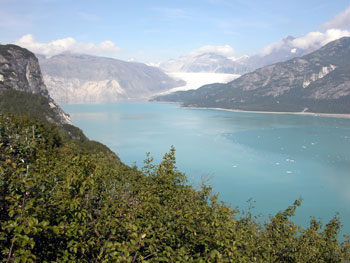
This August 2004 photo further documents the significant changes that have occurred during the 63 years between photographs A and C, and during the 54 years between photographs B and C. Muir Glacier has retreated out of the field of view and is now nearly 5 miles to the northwest. Riggs Glacier has retreated as much as 2000 ft and thinned by more than 800 feet. Note the dense vegetation that has developed. Also note the correlation between Muir Glacier's 1941 thickness and the nearly horizontal line on the mountainside on the left side of the 2004 photograph. This line that indicates the past height of the glacier is called a trimline. Photo courtesy of Bruce Molnia, USGS). |
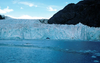
This ship-deck-based August 1980 photograph of Muir Glacier and Muir Inlet, Glacier Bay National Park and Preserve, St. Elias Mountains, Alaska, shows the nearly 200-ft-high retreating tidewater end of Muir Glacier with part of its face capped by a few angular pinnacles of ice, called séracs. Note the icebergs in the ship's wake in the lower right side of the photograph. The location of Muir's terminus is less than a mile from the landward end of Muir Inlet. Photo courtesy of Bruce Molnia, USGS |
| |
|
This photo was taken in September 2003; in the 23 years between photographs, Muir Glacier has retreated more than a mile and ceased to have a tidewater terminus. Since 1980, Muir Glacier has thinned by more than 600 ft, permitting a view of a mountain with a summit elevation of greater than 4000 ft, located in the center of the photograph. A reexamination of the 1980 photograph shows that the summit of this mountain was visible but that it blended in with adjacent clouds. Photo courtesy of Bruce Molnia, USGS |
USGS provides science for a changing world. For more information, visit www.usgs.gov.
Subscribe to USGS News Releases via our electronic mailing list or RSS feed.
**** www.usgs.gov ****
Links and contacts within this release are valid at the time of publication.
~~~~~~~~~~~~~~~~~
Catherine Puckett
USGS Office of Communications
2201 NW 40th Terrace
Gainesville, FL 32605-3574
OFFICE PHONE: 352-264-3532
CELL PHONE: 352-275-2639
FAX: 352-374-8080
EMAIL: cpuckett@xxxxxxxx
