|
Kaibab National Forest creates map products to improve motorist navigation experience
Williams, Ariz., Sept. 28, 2018—For Immediate Release. The Kaibab National Forest is continuing its effort to improve the experience of motorists navigating forest roads by providing
enhanced map products available for free through its website.
This week, new Travel Maps for each of the Kaibab National Forest’s three ranger districts were made available at
http://bit.ly/KNFmaps for public use and download. These digital maps, which are GPS-enabled and intended for use with smartphones and tablets, are specifically
designed to help motorists locate their position while traveling on the forest and using their devices.
The Travel Maps are meant to serve as helpful companions to the official Motor Vehicle Use Map for each ranger district. Motor Vehicle Use Maps are the official documents showing what roads and areas on the forest are open to
motor vehicle travel. However, the large physical size of the Motor Vehicle Use Maps makes them difficult to handle or refer to while traveling. Also, some motorists have reported that the small map scale and spare cartographic design of the Motor Vehicle
Use Maps make it difficult to locate themselves with confidence along the roads and trails and within the areas that they portray.
In response to these concerns, the Kaibab National Forest developed the GPS-enabled Travel Maps, which include much more extensive cartographic design and also feature recreation destinations to help visitors enjoy their forest
experience.
“Our goal is to continue finding opportunities to create more and better map products for use by our visitors and employees,” said Mark Christiano, GIS coordinator for the Kaibab National Forest. “We want people to have the best
experience possible when they visit us, and we know that maps can greatly influence that experience.”
While the Travel Maps are only available digitally, the Motor Vehicle Use Maps for each ranger district are available both digitally and in hard copy format and are also free of charge. Besides these map products which identify
roads and areas where motor vehicle travel is allowed, the Kaibab National Forest also offers
Visitor Maps for a fee. These detailed recreation maps provide information on the forest’s cultural history, campgrounds, wilderness
areas, unique recreational opportunities, wildlife and more.
Members of the public can download the free, digital Travel Maps for their devices as well as the official Motor Vehicle Use Maps for each ranger district by visiting
http://bit.ly/KNFmaps.
Kaibab National Forest information is also available through the following sources:
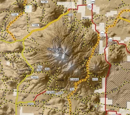
A section of a digital Travel Map displaying more extensive cartographic design intended to better assist motorists in navigating forest roads. Courtesy of Kaibab National Forest.
This electronic message contains information generated by the USDA solely for the intended recipients. Any unauthorized interception of this message or the use or disclosure of the information it contains may violate the law and subject the violator to civil or criminal penalties. If you believe you have received this message in error, please notify the sender and delete the email immediately. To manage your subscription visit http://www.fs.fed.us/news/subscription.shtml |

Attachment:
1650-1_so_TravelMaps_2018_0928.pdf
Description: 1650-1_so_TravelMaps_2018_0928.pdf
