|
Tinder fire update: Firefighters staged for structure protection HAPPY JACK, Ariz., May 11, 2018, For Immediate Release – About
a hundred hard-working firefighters are staged to support suppression of any part of the fire trying to leave the protection lines in the 50 mph wind gusts Friday near the Blue Ridge communities at the Tinder Fire. The local National Weather Service has predicted a breezy day, averaging 20 mph, with high gusts. The
number of personnel assigned to the fire remain at approximately 100, with a dozer being the only resource leaving the fire operation since yesterday. Southwest winds are predicted to move smoke to the northeast toward Winslow and if the wind subsides during
evening hours the smoke may impact Blue Ridge Communities. The public will likely see residual smoke from this fire for several weeks, as tree stumps and other forest
fuels continue to smolder until a significant amount of rainfall extinguishes them completely. Coconino County has issued a “Set” stage for the southeastern-most division of Mogollon Ranch,
and local residents are reminded to remain prepared for any “Ready, Set & Go” event which could be implemented by Coconino County in the case of an emergency evacuation. Tinder Fire Summary.
Date/Time Reported:
April 27, 2018 at 11:43 a.m. by Moqui Tower lookout.
Origin Location:
Origin and Cause Investigators determined that the fire originated in the East Clear Creek drainage approximately 1 mile downstream from Forest Road 95. Forest
Road 95 runs north-south and is located approximately 1.5 miles east of C.C. Cragin Reservoir:
34°33'26.8"N 111°09'41.4"W
Current Size:
16,309 acres.
Topography & Fuels: Steep rocky canyons and cliffs, burning in
grass and understory.
Cause:
Abandoned Illegal Campfire.
Containment: 79 percent.
Current Resources:
100 personnel including two crews, three helicopters, six engines, one dozers and other support personnel.
Resources En Route: None; Additional resources will be ordered
if necessary.
Structures Lost: 33 primary residences, 54 minor structures.
Structures Threatened: None.
Evacuations:
None.
Injuries:
None.
Closures & Restrictions:
·
A large area around the wildfire is currently under a
Closure Order, which prohibits anyone from entering the
area other than authorized personnel such as first responders and firefighting personnel. For details regarding this Closure Order, please see for the Coconino National Forest Orders website at
https://bit.ly/2KKx380.
·
A Federal Aviation Administration temporary flight restriction
remains in place over the area which prohibits Drones and unmanned aircraft systems from entering the area.
·
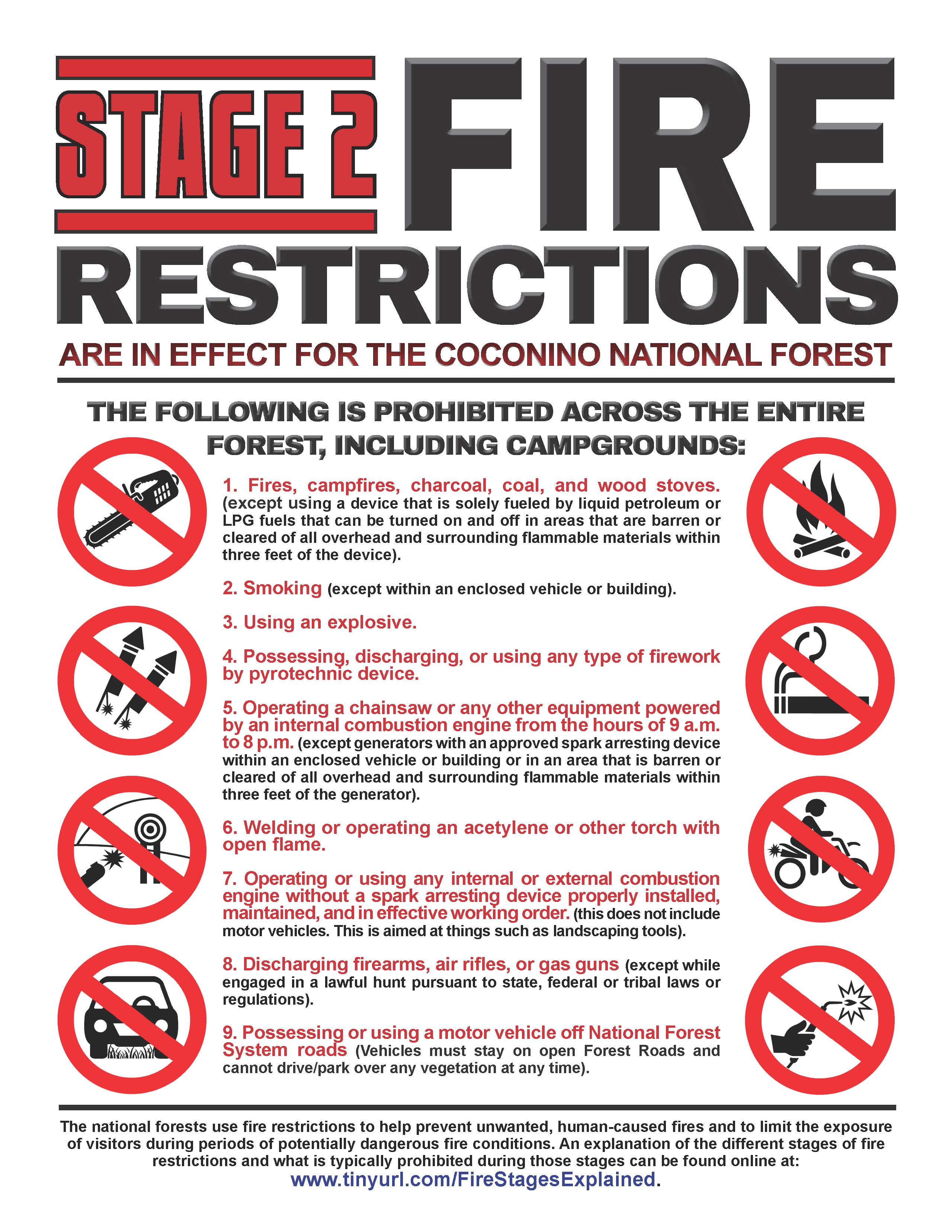
Additionally,
Stage II Fire Restrictions are in effect across the entire
Coconino National Forest, which prohibit a list of activities. Details of these prohibitions can be found online at
https://bit.ly/2rqSQJF.
Smoke Impacts: Internal smoldering will continue to produce residual
smoke. South/southwest winds will produce smoke impacts to Winslow and Blue Ridge communities during the day. In the evening hours smoke will likely impact Blue Ridge communities, drain into canyon areas, possibly impacting areas such as Strawberry, Payson
and the Verde Valley.
Investigation Contacts: If anyone was in the area of Forest Road
95 or East Clear Creek near the origin of the Tinder Fire on April 26 or 27 and has information that could help this investigation, please contact Coconino National Forest Law Enforcement at (928) 527-3511. Tinder Fire Information Resources:
·
The U.S. Forest Service BAER program,
please visit https://bit.ly/2rs80xr.
·
Cococino National Forest, Mogollon Rim Ranger District,
(928) 477-2255
·
InciWeb:
https://inciweb.nwcg.gov/incident/5763/.
·
Coconino County Recovery Info:
(928) 213-2990 or https:/www.coconino.az.gov/tinderfirerecovery
·
Media members only:
(928) 224-8306.
###
This electronic message contains information generated by the USDA solely for the intended recipients. Any unauthorized interception of this message or the use or disclosure of the information it contains may violate the law and subject the violator to civil or criminal penalties. If you believe you have received this message in error, please notify the sender and delete the email immediately. To manage your subscription visit http://www.fs.fed.us/news/subscription.shtml |


Attachment:
StageII Restrictions-COCONINO2018.jpg
Description: StageII Restrictions-COCONINO2018.jpg
Attachment:
COC-NR-5-11-18-TinderFireUpdate.pdf
Description: COC-NR-5-11-18-TinderFireUpdate.pdf
