Pile burns planned over next several days
FLAGSTAFF, Ariz., Jan. 19, 2019, For Immediate Release —
Since snow is expected within the next 48 hours, Coconino National Forest fire managers will be assisting Coconino County with a green waste burn at the Willard Springs transfer station tomorrow morning
immediately west of Interstate 17 at the Willard Springs exit.
Fire managers will also be burning slash piles over the next several days at different locations throughout the Flagstaff Ranger District, which include:
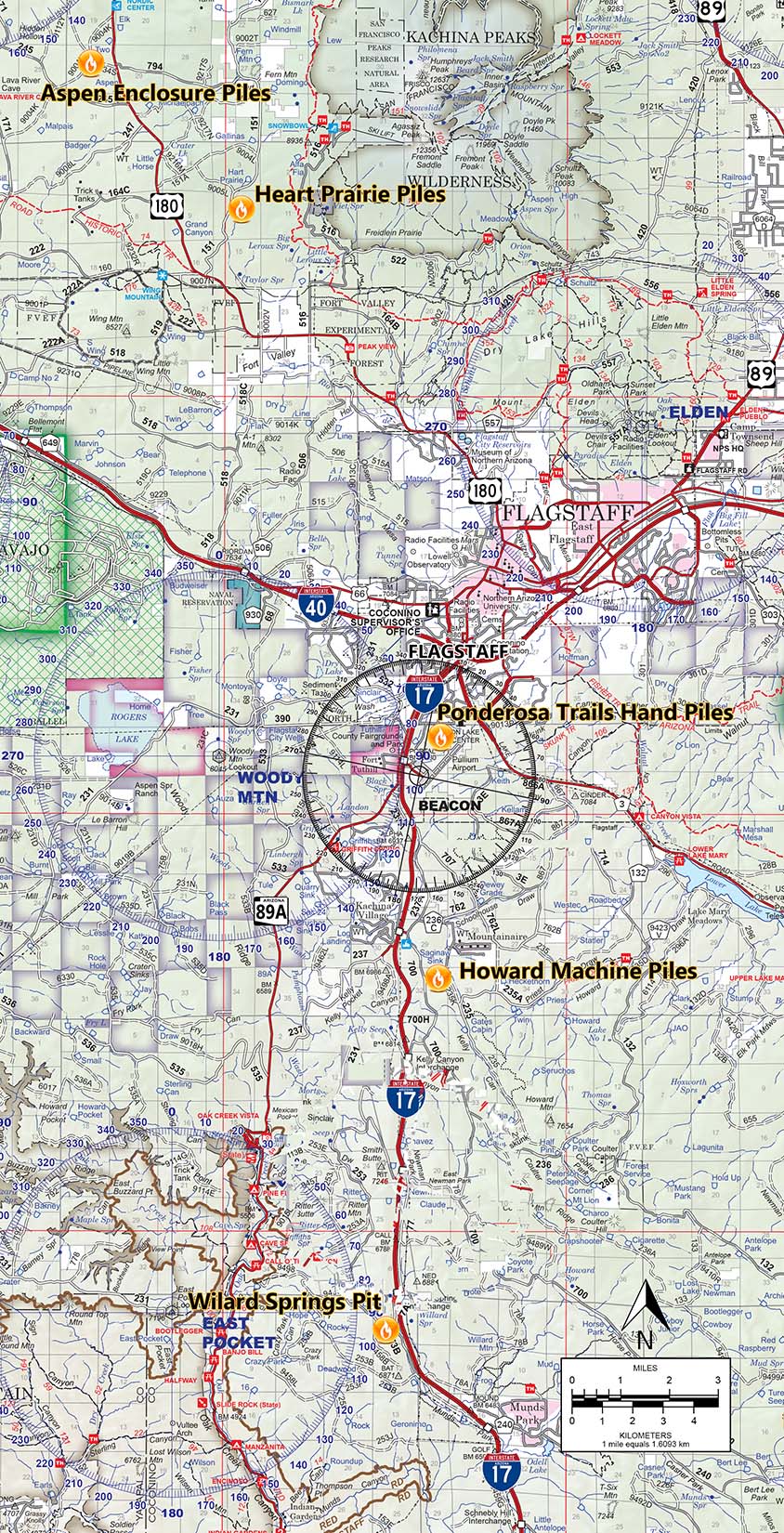
WILLARD SPRINGS PIT (green waste)
When:
Planned ignition will be Saturday (Jan. 20) as weather and conditions allow.
Where: Immediately west of I-17 near Willard Springs exit.
Size: Approximately 1 acre.
Impacts:
Smoke may impact Munds Park communities and drivers on I-17 in the area.
PONDEROSA TRAIL HAND PILES
When:
Planned ignition will be Saturday (Jan. 20) as weather and conditions allow.
Where: North of Pulliam Airport, near Ponderosa Trails subdivision.
Size: Approximately 1 acre.
Impacts: Winds are expected to flow toward the north and northeast, and smoke will be visible to motorists along I-17, I-40, Fort Tuthill and residents of south Flagstaff.
HOWARD MACHINE PILES
When:
Planned ignition will be Monday (Jan. 22) depending as weather and conditions allow.
Where: Just southwest of Mountainaire near I-17; approximately 7 miles south of Flagstaff.
Size: Approximately 300 acres.
Impacts: Smoke is expected to disperse toward the north/northeast and may impact motorists along I-17, as well as residents of Mountainaire and Flagstaff.
HEART PRAIRIE PILES
When:
Planned ignition will be Monday (Jan. 22) depending as weather and conditions allow.
Where: Located about 8 miles north of Flagstaff east of U.S. Highway 180.
Size: Approximately 10 acres.
Impacts: Smoke is expected to disperse to the north/northeast being visible to motorists along U.S. Highway 180.
ASPEN ENCLOSURE PILES
When: Planned ignition will be Monday (Jan. 22) depending as weather and conditions allow.
Where: Located about 11 miles north of Flagstaff west of U.S. Highway 180.
Size: Approximately 1 acre.
Impacts: Smoke is expected to disperse to the north/northeast being visible to motorists along U.S. Highway 180.
Notifications of upcoming burn events are provided regularly by news releases and by the following online resources:
·
Inciweb:
http://inciweb.nwcg.gov/unit/303/
·
Twitter:
www.twitter.com/CoconinoNF
·
Coconino website:
www.coconinonationalforest.us,
(Under News and Events)
·
Sign up to receive news releases:
www.fs.fed.us/news/subscription.shtml
###
|

|
|
George F. Jozens
Deputy Public Affairs Officer
|
|
Forest Service
Coconino National Forest, Supervisors Office
|
|
p: 928-527-3412
gjozens@xxxxxxxxx
|
|
1924 S. Thompson St
Flagstaff, AZ 86001
www.fs.fed.us
  
|
|
Caring for the land and serving people
|
|

