|
Ladies & Gentlemen, Attached is today’s Fuller Fire update and map. Thank you! Respectfully, David
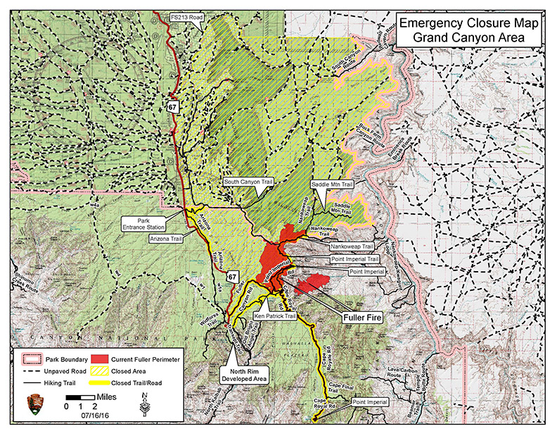
SOUTHWEST INCIDENT MANAGEMENT TEAM #3 Alan Sinclair-Incident Commander Rapid fire spread due to red flag conditions Friday July 16, 2016 Fire: Fuller Fire Containment: 0% Acres: 5,940 Start Date: June 29, 2016 Cause: Lightning Location: Point Imperial, N. Rim Grand Canyon NP Total Personnel: 511 Fuels/Topography: timber, rugged terrain Today: Firefighters reported extreme fire behavior today including short crown runs and group tree torching as rapidly moved to the northeast in the Saddle Mountain Wilderness. However, nighttime burnout operations along Cape Royal
Road successfully held the fire to the north and east of the Road. Fire managers are continuing to assess containment options on the west side of the fire as well as preparing FSR 219 to the north of the main fire. “Today we strategically engaged the fire where it was safe to do so and pulled back in others,” said Jay Lusher, Grand Canyon National Park Fire Management Officer. “Our crews did exactly what they were trained to do in the face of very aggressive fire activity and growth.” Tonight crews will continue to hold existing containment lines and may conduct additional burnout operations where necessary. Tomorrow: Higher humidities may slow additional fire growth. Fire managers will continue to focus on safely keeping the fire east of Highway 67 and north of Cape Royal Road. Crews will also work to the northeast of the Saddle Mountain Wilderness to hold the fire along FSR 8910. Helicopters will continue to drop water as needed to help support firefighters on the ground. Smoke: Smoke from today’s fire activity spread to the northeast reaching into central Colorado. Tomorrow smoke will continue to disperse to the east and northeast with little to no impacts over the canyon. For more information on smoke and air quality please visit: Closures: All USFS areas west of Highway 67 and south of Tater Ridge Rd (FSR 213) and east of House Rock Valley Rd (FSR 8910). Trails: Arizona Trail: Lindberg Hill north to the Park boundary; Ken Patrick Trail: starting at the Uncle Jim Trail junction; Point Imperial Trail; Nankoweap Trail; Saddle Mountain Trail, South Canyon Trail. Road closures include: Fuller Canyon Road; Cape Royal Road; Point Imperial Road; FSR 610; FSR 611. Closures will be in place until further notice. Highway 67 and the North Rim Visitor Center, Lodge and Campground are OPEN as well as FSR22 and Rainbow Rim Trail on Kaibab National Forest. Fire Information: (AM News Release starting 7/17/16) Inciweb: inciweb.nwcg.gov/incident/4845 Text Message: text “follow GrandCanyonNPS” to 40404 Facebook: facebook.com/FullerFire Twitter: twitter.com/GrandCanyonNPS Fire Information Center: 844-684-5411; Recorded Information: 928-638-7688 ### Public Affairs Office Grand Canyon National Park This electronic message contains information generated by the USDA solely for the intended recipients. Any unauthorized interception of this message or the use or disclosure of the information it contains may violate the law and subject the violator to civil or criminal penalties. If you believe you have received this message in error, please notify the sender and delete the email immediately. To manage your subscription visit http://www.fs.fed.us/news/subscription.shtml |

Attachment:
160716 Fuller Fire Update.pdf
Description: 160716 Fuller Fire Update.pdf
Attachment:
Fuller Fire_FIO_Map_Released 07162016.jpg
Description: Fuller Fire_FIO_Map_Released 07162016.jpg
