|
Kaibab National Forest
Website:
www.fs.usda.gov/kaibab Twitter:
www.twitter.com/KaibabNF Inciweb:
inciweb.nwcg.gov
For Immediate Release Contact: Holly Krake, 928-635-5653 August 18, 2014
More Growth on Sitgreaves Complex
WILLIAMS, Ariz. – Yesterday crews reported active fire behavior in the south and southwest areas near Bald Mountain. This fire
behavior was the result of growth from the heat and embers that remained during periods of higher moisture. Due to this resumed activity, crews conducted approximately 90 acres of managed ignitions along FSR 74 to help protect cultural sites within the planning
area. Today crews will continue to monitor the fire perimeter and prepare for possible fire growth along FSR 796 otherwise known as the
‘northern pipeline’. “Having fire in the entire 19,644 acre planning area is not a goal” said Incident Commander, Mario Orozco. “Rather, we monitor fire activity each day to see if it remains active and moving. If we see that natural growth and activity, then
sometimes managed ignitions are necessary for resource protection or to achieve management objectives.” Preparation work over the next several days will include protecting range fences, archeological sites, and other values. Smoke impacts are expected to be minimal for the next several days. For more information on smoke and air quality please visit
www.azdeq.gov
or wildlandfire.az.gov. Date/Time Reported: Sunday July
13th, 2014 Location: 5 miles north, northwest
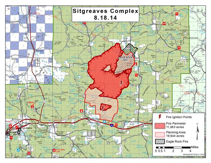
of Parks, Ariz. Cause: Lightning Size: 11,063 acres Landscape/Fuels:
Ponderosa Pine Fire Behavior:
Majority Low to Moderate Intensity Get fire activity updates and maps 24 hours-a-day: Fire Information Line: 928-635-8311 Inciweb:
inciweb.nwcg.gov Text Message: text ‘follow kaibabnf’ to 40404
Map of the 11,063 acre Sitgreaves Complex as of August 18, 2014.
Holly Krake, MSEd Fire Information Officer USDA Forest Service Kaibab National Forest- South Zone 742 S. Clover Road Williams, AZ 86046 p. 928-635-5653 f. 928-635-5680
This electronic message contains information generated by the USDA solely for the intended recipients. Any unauthorized interception of this message or the use or disclosure of the information it contains may violate the law and subject the violator to civil or criminal penalties. If you believe you have received this message in error, please notify the sender and delete the email immediately. |


Attachment:
1650-1_d1_SitgreavesComplex_2014_0818.pdf
Description: 1650-1_d1_SitgreavesComplex_2014_0818.pdf
