|
Kaibab National Forest
Website:
www.fs.usda.gov/kaibab
Twitter:
www.twitter.com/KaibabNF Inciweb:
inciweb.nwcg.gov
For Immediate Release Contact: Holly Krake, 928-635-5653
July 15, 2014
Sitgreaves Fire Also Managed to Benefit Forest
WILLIAMS, AZ – As favorable conditions continue across the Kaibab National Forest, fire managers plan to add the Sitgreaves Fire to the two fires already achieving resource benefits on Tusayan
and Williams Ranger Districts. While these fires are managed to benefit the ecosystem, safety, and heritage, they can last several weeks or more. “Our goals for this fire include low to moderate intensity burning as conditions allow” says Assistant Fire Management
Officer, Mike Uebel. “Meeting those objectives may take longer periods of time to accomplish successfully. Williams Ranger District: Currently 11 acres in size, the Sitgreaves Fire is located approximately
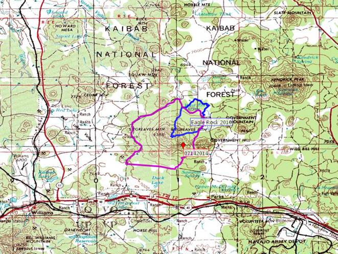
5 miles northwest of Parks, AZ. To plan for fire growth, officials have identified a specific planning area of approximately 14,800 acres in which the fire could spread. Smoke may be highly visible from I-40. Currently 3 acres in size, the Duck Fire is located approximately 3 miles northwest of Parks, AZ. Due to constant moisture, fire growth and behavior has been limited.
Tusayan Ranger District: Currently 200 acres in size, the McRae Fire is located approximately 5
miles southeast of Tusayan, AZ. To plan for fire growth, officials have identified a specific planning area of approximately 11,000 acres in which the fire could spread. Crews are conducting managed ignitions as needed within the planning area. Smoke may become
highly visible from Highway 64. While varying monsoonal precipitation and winds are likely to change fire behavior and growth over the next several days, general fire behavior is anticipated to be low to moderate intensity. Get fire activity updates and maps 24 hours-a-day: Fire Information Line: 928-635-8311 Inciweb:
inciweb.nwcg.gov Text Message: text ‘follow kaibabnf’ to 40404
To plan for fire growth, officials have identified a specific planning area (purple shape) of approximately 14,800 acres in which the fire could spread. The blue shape represents the
Eagle Rock Fire of 2010. Holly Krake, MSEd Fire Information Officer USDA Forest Service Kaibab National Forest- South Zone 742 S. Clover Road Williams, AZ 86046 p. 928-635-5653 f. 928-635-5680 This electronic message contains information generated by the USDA solely for the intended recipients. Any unauthorized interception of this message or the use or disclosure of the information it contains may violate the law and subject the violator to civil or criminal penalties. If you believe you have received this message in error, please notify the sender and delete the email immediately. |
Attachment:
1650-1_so_McRae_Duck_Sitgreaves_Fires_2014_0715.pdf
Description: 1650-1_so_McRae_Duck_Sitgreaves_Fires_2014_0715.pdf


