|
Please see attached news release regarding the resource benefit Skinner Fire on the Tusayan Ranger District near Tusayan, AZ on the Kaibab National Forest.
Thank you,
Holly Krake, MSEd Fire Information Officer USDA Forest Service Kaibab National Forest- South Zone 742 S. Clover Road Williams, AZ 86046 p. 928-635-5653 f. 928-635-5680
Kaibab National ForestWebsite: www.fs.usda.gov/kaibabTwitter: www.twitter.com/KaibabNF
For Immediate Release Contact: Holly Krake, 928-635-5653July 31, 2013Skinner Fire Helps Build Tusayan Fire History
TUSAYAN, AZ – On July 26th, 2013 a lightning caused fire was reported on the Tusayan Ranger District in the Skinner Ridge area off of FS road 343. Named the Skinner Fire, this fire was immediately noted by Fire Management Officer, Quentin Johnson, to be in a location largely surrounded by previous wildfire and prescribed fire, but unburned itself. To increase protection ability, reduce ground fuels, and return fire to the ecosystem, the Skinner Fire will be allowed to spread naturally. “We have a hole in the map that has not seen fire in our recorded history. This is a great opportunity to return fire where it is ecologically needed and historically accurate” said Johnson.
Forecasted drying trends will support fire growth though intensity is likely to remain low with creeping, smoldering, and some backing fire behavior. To plan for fire growth, officials have identified a specific planning area in which the fire will be allowed to spread. At this time, the 6 acre fire is spreading naturally with 1-2 acre growth potential each day over the next several days. Other management options, such as perimeter road ignitions, may be utilized for objectives such as firefighter safety and resource protection.
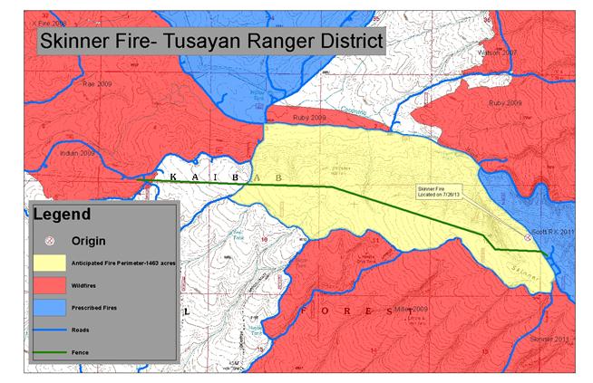
Date/Time Reported: Friday July 26th, 2013 Location: 5 Miles East of Tusayan Cause: Lightning Size: 6 Acres Landscape/Fuels: Ponderosa Pine Fire Behavior: Low intensity, 6-12 inch flame lengths Planning Area: 1,463 acres
Smoke impacts should be minimal, if any, for the Tusayan area, south rim of the Grand Canyon, and surrounding communities. However, smoke may become highly visible from Highway 64 as the fire is currently showing an approximately 400 foot smoke column. If managed ignitions occur, the smoke column could increase to over 2,000 feet. Winds are forecasted to be southwest around 8 mph.
For additional information, please call Holly Krake (USFS), Fire Information Officer, 928-635-5653
-USFS-
Map of the Skinner Fire planning area in yellow.
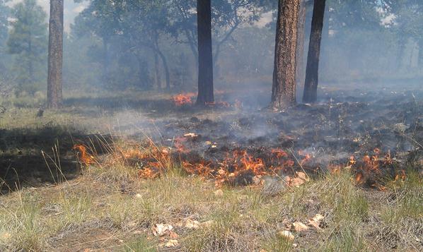
Low intensity fire behavior as seen on the afternoon of July 30th, 2013.
This electronic message contains information generated by the USDA solely for the intended recipients. Any unauthorized interception of this message or the use or disclosure of the information it contains may violate the law and subject the violator to civil or criminal penalties. If you believe you have received this message in error, please notify the sender and delete the email immediately. |


Attachment:
1650-1_d4_Skinner_Fire_2013_0731.pdf
Description: 1650-1_d4_Skinner_Fire_2013_0731.pdf
